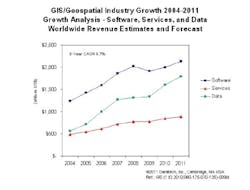
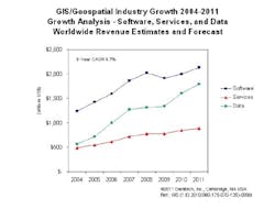
CAMBRIDGE, MA, Jan. 19, 2011 -- According to a just released study by Daratech, (www.daratech.com) an industry analyst group specializing in GIS/Geospatial market dynamics, sales of GIS/Geospatial software, services and data grew a robust 10.3% in 2010 to US$4.4 billion.
After a dismal 2009 that saw industry revenues shrink 2% as the world economy suffered what some have called the most severe economic downturn since the 1930s, GIS/Geospatial sales bounced back in 2010 and are now forecasted by Daratech to grow more than 8.3% to almost US$5 billion this year.
"Demand for GIS/Geospatial products is driven by an increasing global need for geographically correlated information," said Charles Foundyller, Daratech's CEO. "As more and more Web sites such as Google Earth and consumer navigation systems such as TomTom bring awareness of the power of linking business and consumer information with their geography, Geo-enabled apps will become the norm."
So far, the influence and power of GIS/Geospatial technologies have largely gone unnoticed by investors and the general public. Many may find it hard to accept that an industry with annual worldwide sales of less than one hundredth of one percent of global GDP can make a discernable difference, yet technologies developed by this industry are contributing mightily to an ever growing range of activities in all sectors of the world economy. This has not gone unnoticed by some fund managers who see the possibility of explosive industry growth within a relatively short time frame.
"Growing awareness of Geo-enabled software is good news for GIS/Geospatial industry investors and other stakeholders who, in some cases, have waited a long time for the knee in the J curve," observed Foundyller.
The scope of where GIS/Geospatial technology makes a difference is impressive, and growing. It contributes to national security; helps governments at all levels manage their natural resources and infrastructure; assists an ever increasing number of businesses in a growing range of industries to streamline operations; and it helps individuals in their daily lives in matters such as locating a good place to live, a good vacation spot, navigating their car, or finding people with similar interests that live nearby. Indeed, from creating policies for managing forests and wildlife, to discovering the best place to locate a manufacturing plant, distribution center or shopping mall, managing telecommunications, utility or municipal assets, geospatial technology is contributing mightily to better informed decision-making.
GIS Data is today the fastest growing segment of the GIS/geospatial business. GIS Data has grown at a compound annual rate of 15.5% for the last eight years -- about twice the rate of growth for software and services. "GIS Data is to GIS/Geospatial apps what software is to computers," says Foundyller. "Without it, GIS/Geospatial apps have nothing to tell us." Consequently, as more location-related data becomes available, the use and scope of Geospatial analyses is sure to grow dramatically.
"Data sales, Defense and Security apps, mobile device apps, and Web apps, will be the top business drivers for the industry," says Foundyller. In fact, these are becoming much easier to develop with specialized software such as ESRI's ArcGIS no cost API for Apple's iPhone and iPad. "But what is really exciting is that advances in image processing technologies are accelerating and refining GIS data production by orders of magnitude, and creating a new feedstock for apps of all kinds."
Business opportunities for GIS/Geospatial products and services have never been better. In the Unites States and elsewhere national governments are funding surveillance satellites as well as non-defense remote sensing systems with amounts that are multiples of today's geospatial industry's annual sales. In order to organize and correlate all the information that such systems will collect, GIS databases and related GIS analytical technologies will be in increasing demand. At the same time, the explosive growth of ever more powerful interconnected mobile devices and the ever-increasing rates of information flow that their networks support will create even broader opportunities for geospatial apps for these devices and collaterally for Web/Cloud apps as well.
"Another segment to watch is the so-called geo-enabled engineering segment," says Foundyller. Today, CAD systems, used to design the built environment are typically not designed to interoperate with GIS systems. Consequently, designers of buildings, roads, bridges and other types of infrastructure don't have an easy way to understand the impact of their surroundings on their designs. This is changing. In future we expect CAD systems and GIS systems will become far more closely linked, so that architects and city planners, for example, will be able to easily see their designs, in situ, together with other location-specific information related to their designs.
"Our research indicates that the geospatial industry continues to grow faster in regions outside of Europe, North America and Asia Pacific," says Foundyller, However, this region accounts for just 8% of total industry sales, so it may be a while before it can make significant contributions to the industry's overall growth. On the other hand, North America which accounts for almost half the industry's annual sales has enjoyed an 11% compounded annual growth rate for the last 8 years, while Asia/Pacific with a 8.7% CAGR leads Europe, a region that grew at a slower 7.9% compound annual rate.
Overall, the geospatial industry depends very much on it's base markets in North America and in Europe; however, strong growth in Asia/Pacific, particularly in China, India and other emerging economies of the world should help ensure that the industry's growth continues strong into the foreseeable future. For 2012 through 2015 Daratech is forecasting double-digit geospatial industry revenue gains as the factors fueling growth gain more traction.
Daratech's GIS/Geospatial Market Report is available for purchase on www.daratech.com.
Charles Foundyller is a GIS and AECO industry analyst based in Cambridge, Massachusetts, USA.
###


