By David MacIntyre
In an unprecedented display of cooperation and collaboration, the agencies responsible for sustainably managing the groundwater supply in Central Florida have joined forces with public utilities and the local agricultural industry -- the primary consumers of this water -- as well as environmental interest groups and other stakeholders to develop a unified regional water supply plan. In so doing, they are bringing greater order to a water allocation permitting process that, until now, has been increasingly contentious and based on inconsistent criteria.
The Floridian Aquifer is a layer of saturated carbonate rock that underlies the entire state of Florida as well as parts of Alabama, Georgia, Mississippi, and South Carolina. The aquifer provides an economical source of groundwater to many municipalities in North and Central Florida, including Tallahassee, Jacksonville, Orlando, and Tampa. The state's five water management districts regulate withdrawals for consumptive use and are responsible for maintaining a sustainable groundwater supply.
In 2006, three of the water management districts -- South Florida, Southwest Florida, and St. Johns River -- identified a region in Central Florida where groundwater supplies were expected to be insufficient to meet future demands (see Fig. 1). Because this region overlaps their borders, the three districts coordinated their efforts to develop a plan to quantify and consistently manage the groundwater supply in the region.
The effort gained momentum, and by 2010, seven of the region's largest utilities, along with the Florida Department of Environmental Protection, Florida Department of Agriculture and Consumer Services, and other stakeholders, formed a collaborative alliance with the three districts to develop a regional management approach to the Floridan Aquifer. Dubbed the Central Florida Water Initiative (CFWI), the project set out to determine the quantity of sustainable groundwater available to the region.
Parsons Brinckerhoff served as technical consultant on behalf of a consortium of five utilities collectively known as the STOPR Group -- the City of St. Cloud, Toho Water Authority, Orange County, Polk County, and Reedy Creek Improvement District -- which focused its efforts to engage as an active and influential participant in the districts' planning process. The main task was to quantify how much groundwater was available, identify factors that could positively or negatively affect the supply, and facilitate the development of technical tools that would support solutions planning and rulemaking that would define how groundwater allocations are issued to all stakeholders in the future.
Data Dilemma
Traditionally, the water management districts require permit applicants to provide justification for the water use they are requesting and to produce groundwater models that assess how much additional environmental impact the planned use would create by taking more water out of the aquifer system. Applicants hire environmental scientists to conduct wetland assessments and help determine potential impacts, but the districts conduct their own studies, and they may disagree with the applicants' assessments. The competing interests, each with their own experts, are then left to debate the validity of the data assessments as well as the source and degree of potential impacts. In many instances, disagreements arise from a fundamental dilemma: Neither party has a definitive measure of the sustainable amount of available groundwater.
One of the areas of debate for the STOPR Group with the CFWI was the groundwater modeling methods that were being applied. For instance, there was concern that the way irrigation was represented would underestimate the amount of water being put back into the system.
Stress Risk Assessment
A significant obstacle was a dearth of historical hydrologic data about the regional wetlands' water levels. Environmental condition assessments had been conducted previously on several hundred individual wetlands by both the districts and applicants, but there was no generally-accepted method for relating the occurrence of wetland stress to altered water levels, nor was there a method to make reliable judgments about the environmental health of the vast majority of wetlands for which no assessments existed.
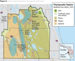
While the technical team had a reasonable idea of the existing range of water levels in a few dozen wetlands in the CFWI study area, it had no data from thousands of other wetlands that may be affected by groundwater withdrawals (see Fig. 2), necessitating reliance on available data to make a best estimate for all of the wetlands. The solution was to create a new statistical wetland stress risk assessment method (SWSRAM) to calculate the probability of a wetland becoming stressed due to a change in hydrologic conditions. The method uses hydrologic data from a period of time consistent with the CFWI groundwater model calibration period, which was developed by merging data from multiple sources, including the districts' prior wetland assessments.
Engineers created statistical distributions of the historical water levels for 44 wetlands in the CFWI region where these hydrologic data were available and then used them to calculate the probability of induced stress occurring through changes in the water level.
The Hydrologic Index
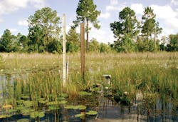
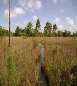
The health of wetland systems is strongly influenced by a variation of water levels. Too much variation, or not enough, can cause a wetland to become stressed. Observable indicators of wetland stress include an abundance of fallen trees, invasion of upland species and fissuring or settling of organic soils.
Work done by Parsons Brinckerhoff showed that the probability of hydrologic stress occurring in wetlands could be related to what we've termed a Hydrologic Index, which is indicated by the Greek character theta (Θ). The index represents the difference between the wetland edge reference elevation (ERE) and the water elevation that is exceeded 80 percent of the time (the 80th percentile, or P80), based on historical observations of the site. The greater the value of Θ, the greater the variance in water levels during the observation period.
By plotting cumulative frequency water level graphs for multiple similar wetland systems, and noting with each observation whether the system was healthy or stressed, the appropriate range of water levels for healthy systems could be discerned.
CFWI Survey Sample
The project team identified 44 wetland locations with recent stress status evaluations and sufficient hydrologic data available to calculate a P80 low water elevation based on water levels for the period 2006 through 2011. While a longer period would have been preferred, the need to find a consistent period in order to calculate consistent P80 values for as many sites as possible constrained the analysis. This situation exemplifies a common dilemma: To avoid creating large impacts that may be irreversible on normal human timescales, one has to make judgment calls based on less-than-perfect data sets.
For the purposes of the study, elevation values were converted from a standard U.S. survey metric (NGVD29) -- which is tied to mean sea level -- to the depth below the ERE. This enabled direct comparison of data from multiple wetlands set at different elevations in the landscape.
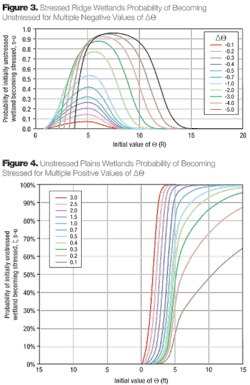
The study sites were divided into two types: plains wetlands and ridge wetlands. For each type, the statistical distribution of Θ was assessed separately for stressed and unstressed wetland systems. In each case, the Θ value distributions were all reasonably approximated by the normal distribution (see Figs. 3 & 4).
Quantifying the Change
When the distribution of Θ for stressed and unstressed systems was compared, it was demonstrated that for any given value of Θ, it was possible to calculate the probability that a randomly-selected wetland would be stressed at that value.
The probability of induced stress occurring can be tied to the change in Θ from its initial value to some future value. Since Θ = ERE – P80, and since ERE is a constant value for any given wetland, it follows that the change in Θ is equal to the change in the P80 value. If the future value of Θ is further from the mean value of Θ for healthy systems, the probability of an adverse change in wetland status becomes greater.
This scenario, where the condition of a particular wetland and its initial Θ value is known and its P80 value can be determined from hydrologic analysis, is the ideal case. With this information, it is possible to calculate a site-specific probability that the wetland's condition will be altered based on the anticipated water level change associated with a given groundwater withdrawal request.
A Probability Problem
The next challenge was to find a way to calculate the probability that a wetland will experience a change in stress status when one or more of the data inputs are unknown. This was the case for the vast majority of the thousands of wetlands within the CFWI study area because there were insufficient resources to monitor them all.
When the initial value of Θ cannot be determined, reliance on knowledge of the probability distribution of all possible Θ values is necessary. This probability distribution is derived for each wetland type from the observed values in the survey sample data set.
For each possible initial value of Θ, the likelihood that the magnitude of water level change predicted from the CFWI groundwater model will induce a stress status change is determined. This results in a joint probability density function -- the combined probability of a particular initial value of Θ and its corresponding probability that the predicted magnitude of future water level change will induce a future change of stress status.
The joint probability is calculated by multiplying the two probability values. Integrating this joint probability density function across the whole range of possible Θ values, and dividing by the integral of the Θ probability density function across the whole range of possible Θ values, results in a population-weighted average of the overall likelihood of inducing stress status change in a given wetland.
There is always a loss of prediction precision when there is less information on initial conditions. Nevertheless, if the probability of stress status change across the entire population of wetlands in the study area is accumulated, the mean value starts to assert itself strongly, and a good estimate of the total area of wetlands that will experience a change of stress status across the region can be developed.
Area of Effect
Once it is determined that a change of stress status is likely, the next step is to gauge the magnitude of the potential threat. How much of the wetland area within the CFWI study area would be endangered?
The CFWI groundwater model divides the study area into a high-density grid. The population-weighted average probability of stress change at each wetland location in each cell of the grid can be calculated based on the corresponding future change in water levels anticipated for that cell. Using geographic information system data, total acreage of each wetland type (plains/ridge) within each cell of the grid can be determined, as well as the areal probability contribution of future stressed wetlands from each cell. By summing these values, the total acreage of wetlands within the entire CFWI study area and the percentage of those wetlands that are likely to be stressed under future conditions can be identified.
Prior to the development of this tool, environmental scientists had no objective, repeatable way to connect physical wetland health to water level change. The power of this method is that it allows one to make quantitative assessments of the risk of adverse environmental consequences to wetland systems as a result of future water management practices. It makes it possible to predict -- and therefore take steps to prevent or mitigate -- potential environmental harm. In areas with extensive wetland systems, this can be a critical decision path for maintaining an environmentally sustainable future condition.
The new modeling method developed for the CWFI study enables regional planners to quantitatively and repeatedly predict where harm could occur due to water level changes, providing a better understanding of how much groundwater is available and how much each entity could receive. The SWSRAM, together with other environmental constraint measures, has now been incorporated into water use planning in Central Florida. Using these environmental protection constraints, the CFWI process has resulted in an estimate that there is approximately 850 million gallons per day (MGD) of groundwater available for use.
About the Author: David MacIntyre is a vice president with Parsons Brinckerhoff. He served as project director of the Central Florida Water Initiative Groundwater Availability study and led the development of the Statistical Wetland Stress Risk Assessment Method.


