By Mary Jo Wagner
Located in Southwestern Montana, Bozeman is a mid-size municipality known for its mix of outdoor recreation, college-town spirit and "big city" amenities -- an inviting atmosphere that has spurred a population boom. All of this new development, as well as existing infrastructure, is being supported by 93 miles of aging, unmaintained stormwater pipelines and a paper-based asset information system comprised of 100-year-old hand-drawn engineering maps stored in a basement.
Bozeman's stormwater system has traditionally been on the "breaking news" side of the city's public works department (PWD). Unlike its water and sewer operations, which have been a daily focus for the department, stormwater typically only flowed into the spotlight because of an incident or emergency that demanded immediate attention. Once an incident was resolved, stormwater would recede to back-page news again, even though it had been silently producing front-page news for decades.
Indeed, a few regular peeks under the city's road surfaces would have alerted personnel to significant infrastructure failings, insufficient retention ponds, high levels of contaminants in main waterways, and degrading water quality.
"Our stormwater system is about 100 years old, and it has gone largely unchecked," said Kyle Mehrens, a GIS technician in PWD. "Historically, we haven't had an effective GIS-based inventory or map of our stormwater system, and we haven't had any full-time stormwater staff. So any work done on the system has been predominantly response-based. That has made it very challenging to understand the connected infrastructure, to determine its condition and issue maintenance or repair work, and to plan for needed improvements."
This lack of focus, however, led to breaking news when the Montana Department of Environmental Quality (DEQ) audited PWD and found it to be in violation of its federally issued municipal separate storm sewer system (MS4) permit. The infringement was the lack of a comprehensive stormwater system map. As serious as the violation was, it also helped launch a long overdue mapping project in 2012 that would bring the underground workhorse to light.
The DEQ's 2011 audit set the city on a new course, providing the public works GIS department with the funding and government support to launch the $200,000 stormwater mapping project. However, finding a way to acquire the data breadth and depth sought within a one-year timeframe and with an initial project team of two posed a challenge. In addition, the nature of stormwater mapping would require the field crew to work in the middle of roadways, potentially putting them and the public at risk. Given the schedule, data requirements and safety elements, they acquired two Trimble® GeoExplorer® 6000 series GNSS handheld units. The handhelds allowed them to be highly mobile, efficiently collect centimeter-accuracy data and readily integrate the location data with their Esri ArcGIS system.
Field of Discovery and Painful Truths
In January 2013, Mehrens prepared for the fieldwork scheduled for that spring. After months of research, he developed a set of 13 unique stormwater data layers such as manholes, pipes and inlets. Each layer was then given its own set of critical attributes such as the size of a manhole cover, its depth and its width.
Once the feature classes were established, Mehrens created a customized data dictionary in the Geo 6000's software, which would prompt the user to record particular attributes of each object. This unique data would complement the standard attributes provided by the handheld unit such as the horizontal coordinates, elevation and positional accuracy of each surveyed point.
Each morning, the two-person field crew would consult a combination of in-house aerial photos and paper maps to determine which area of the city they would survey. Once on site, one person would ready the Geo 6000, set the unit on each stormwater feature and record the point, while the other would drive to the next mapping section. While the positioning data was being logged, the technician would also record critical attributes pertinent to the asset as well as environmental surroundings such as the presence of a curb and its type. After all feature data was collected, the mapper would move to the next set of objects and repeat the process. Typically, the field crew would map about 200 features in an eight-hour day.
Using data from a nearby Trimble NetR9® GNSS base station and Trimble GPS Pathfinder® Office software, Mehrens would process the Geo 6000 data within one hour of receiving it from the field. Once processed and checked, he would export the data into the Esri database and assign unique facility IDs to each feature collected. Because of the software development he had previously conducted, some of the stormwater layers in the GIS were automatically populated with the GPS data attributes, creating an efficient workflow.
Mehrens and his team mapped more than 10,000 features in just four months. They captured about 95 percent of the existing infrastructure, including 93 miles (150 km) of pipe, 1,276 manholes and 3,059 inlets. Further, they discovered some sobering truths about what lies underneath the surface: heaps of trash, sediments, paint residue, industrial effluent, 10 miles (16 km) of pipe in serious disrepair, and 196 of 263 detention ponds destroyed. However, those findings, coupled with the data detail collected, have given them the insight to design substantial stormwater program improvements.
Stormwater Anew
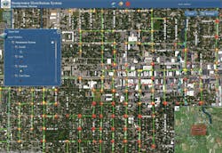
The first of these improvements was the development of an ArcGIS-based interactive stormwater map -- the key to MS4 compliance -- that offers a dynamic, layered blueprint of Bozeman's entire stormwater network, down to the individual inlet or manhole. Users can access the online map, click on any asset feature and view its associated attributes such as a manhole's invert or a pipe's size. When new infrastructure is mapped, it is immediately added to the dataset, keeping the map up to date.
Having such an accurate, digital and visual record of the stormwater system has served as a boon to productivity and as a communication tool for PWD.
The TV crews -- the teams that use remote-controlled video cameras to assess the structural integrity of the underground pipelines -- proactively use the map to determine pipe sizes before going on site. As it can take nearly one hour to change a camera's wheel set, knowing the size of a pipe in advance ensures that they have the proper wheel sets to fit inside each pipe, saving valuable time in the field.
The map enables Bozeman's contracting community to identify where they need to erect stormwater control measures around their construction sites. Emergency responders can consult the map to track and monitor the path of a pollution event and prevent it from reaching waterways. Planners use the map in their consultations with developers to ensure that stormwater practices are implemented. Citizens can also use the map to report an event or to talk intelligently about stormwater concerns they have.
Stormwater can now be integrated with PWD's asset management system. This integration enables crews to plan, track and update maintenance and repair work on any given piece of the network. It also provides the ability to achieve further permit compliance because they have the data and tools to produce detailed maintenance reports -- a major component for compliance.
Perhaps most significantly, the mapping project has provided the factual platform to drive the expansion of the stormwater program. With a complete inventory of the infrastructure and its condition, Mehrens and his colleagues were able to successfully propose a significant improvement plan.
The 15-year, $1.2-million multi-faceted plan will add five full-time employees, dedicate $450,000 a year to clear $7 million of deferred maintenance, and provide for system improvements such as stormwater treatment devices. These enhancements will be funded by new rate models that will more fairly charge residents and will increase revenue for PWD.
"All of this success comes down to great data. The mobility and high accuracy provided by the GPS handheld gave us the speed and GIS data quality we needed to completely change our stormwater business," said Mehrens. "Our knowledge of our stormwater system has transformed from one of ‘we think' to one of ‘we know,' and that enables us to properly manage our infrastructure to address the bigger issues of water quality and public safety."
About the Author: Mary Jo Wagner is a Vancouver-based freelance writer with 20 years of experience covering geospatial technology. She can be reached at [email protected].
More WaterWorld Current Issue Articles
More WaterWorld Archives Issue Articles
