Beach well intakes improve feed-water quality
By Joshua Schwarz
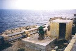
Beach wells and galleries extracting groundwater of seawater quality can provide a reliable quantity and better quality water than surface intakes due to natural filtration and underground detention.
Experience in the use of similar beach wells and galleries as intakes for Seawater Reverse Osmosis (SWRO) is still limited; however because of their positive effects on feed-water quality, non-surface intakes promise an opportunity for better efficiency, reliability, cost effectiveness, and performance of desalination plants, particularly SWRO plants.
Non-surface intakes include beach wells, seabed filtration and inflow galleries. These different intakes represent design variations that use the same principle — extracting filtered seawater from below the surface near the shoreline. Each of these intakes has advantages, capabilities, suitabilities and cost-effectiveness for different site conditions.
Tahal Consulting Engineers of Tel Aviv, Israel, carried out a study for the Middle East Desalination Research Centre (MEDRC) in Oman to provide a comprehensive state- of-the-art document on using beach wells, and similar non-surface seawater intakes for SWRO systems, and to develop and verify the criteria for the choice and design of these types of seawater intakes.
The study identified site-specific hydrogeological conditions that determine the choice of intake type and assess its feasibility. The main properties are aquifer lithology, thickness and hydraulic conductivity. Feasibility is assessed in terms of anticipated direct and indirect costs, advantages of the proposed technology in the desalination process and anticipated problems in its implementations.
The first and main concern in comparing different water intakes is the direct cost of feed-water at the inlet of the SWRO plant (after pretreatment), and the reduction of treatment cost due to the improved feed-water quality.
The second concern are indirect costs representing the environmental effects of pumping seawater on the groundwater system.
Three types of models have been used for the quantitative assessment of these concerns: geohydrological model; techno-economic model; and models for estimating energy requirements of desalination based on the chemical composition of the feed water and the recovery ratio.
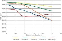
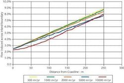
A geohydrological model (SUTRA) represents the performance of intakes in terms of quantity and salinity of the pumped water and their variations over time in addition to the impact of the intakes on the groundwater inland and the eventual reduction of inland availability of groundwater. This special dual fluid simulation model was applied to study geohydrological considerations, to set the optimal location and depth of the intake, and to assess the environmental impacts on fresh groundwater stock and its use.
A techno-economic model represents the cost elements of the total system including delivery of product water and disposal of the brine produced. This model also includes an assessment of indirect costs, based on the results of the geohydrological model. The model is used for compiling and assessing the values of cost elements for the given site properties.
Tahal Consulting Engineers compiled the data for the study through a literature survey, direct contacts with qualified persons, formulating questionnaires and analysing responses.
Study findings
Cost estimates prepared for conditions typical to the Israeli coastal plain show that the cost of desalinated water can be reduced by 17% when replacing a surface intake with beach wells. The cost reduction is only 9% when considering indirect environmental costs of beach wells.
Beach wells using water for cooling installations and for swimming pools were installed in Israel in the early 1960s near the Mediterranean Coast. The typical dimensions of such a well are 90-m total depth with a 20-m screen with a diameter of 10 inches. These wells are located usually at a distance of 20 m from the coastline. The discharge rate is about 4,000 m3/day and pumped seawater is diluted with about 10% of fresh aquifer water.
Tahal consultants carried out a survey on the performance of beach wells in Malta, Balearic Islands, Canary Island, Greece Islands and Arabian Gulf countries. The survey revealed two types of problems in beach well performance: operation and maintenance; and corrosion and other problems resulting from the high ion concentration of seawater.
Improper or poor well construction have caused many major problems in operating wells, particularly with high salinity water. The most common causes of well failure are:
• Borehole collapse;
• Corrosion of casing;
• Improper or defective construction techniques;
• Growth of organisms within the well bore;
• Water intrusion from another source;
• Crusts in the open hole or screened section of the well bore.
The risks of such damages can be minimised by following proper design criteria, as defined in the study. To avoid adverse effects on inland freshwater, the best location of the intake would be in the seabed as far as possible from the coastline. However, only continental sites are usually considered due to the high cost involved in off-shore drilling and abstraction. The best of these are sites located close to the coast-line.
The intake depth is determined by the quantity to be abstracted and by the depth required for effective filtration. It is determined also by the desire to minimise adverse effects on the freshwater zone. The intake should be located as deep as possible and feasible when the aquifer is not stratified. Terragenous, granular aquifers are the most favourable sites for SWRO beach wells.
Proposed design criteria
The freshwater fraction in the pumped water can be minimised by locating wells as near as possible to the coastline. Wells should penetrate the depth of the aquifer and reach its base.
The pumping capacity of beach wells depends quadratically on the thickness of the aquifer. The minimal saturated thickness of the aquifer should not be smaller than 50 m.
Phreatic aquifers should be preferred over confined aquifers, which may have their seawater boundary at a large distance from the coastline, by that decreasing the rate of seawater flowing to the wells. The upper aquifer should be selected in a multi-layer aquifer.
Under the hydrologic conditions prevailing in the coastal plain of Israel, the maximum pumping capacity of a beach well battery running parallel to the coastline cannot exceed 15,000 m3/day/km. The assumed design capacity will be 10,000 m3/day/km.
The resulting spacing between wells will be 240 m with a single well capacity of 2,400 m3/day.
When assuming pumping of 10,000 m3/day/km and a recovery ratio of 50%, the maximum capacity of the SWRO plant that justifies non-surface intake is 25,000 to 50,000 m3/day, considering the cost of the collecting system.
Site exploration is required to assess the relevant hydrological characteristics of the selected coastal stretch. The first step is taken by collecting and reviewing available data. In case of insufficient information concerning the local structure, stratigraphy and hydrogeological configuration, the needed data must be generated using several different approaches.
Thickness, stratigraphy, hydrogeological outline and lateral extension of aquiferous units can be obtained by means of exploratory slim holes or exploratory/production wells, and/or a network of observation wells.
Later, after drilling within a strip parallel to the sea shore, the boreholes will serve, inter alia, as calibration points between the lithological and hydro-stratigraphic profile, and the geophysical findings. Suggested geophysical methods are the VES (vertical electrical sounding) and the TDEM (time domain electro-magnetic) surveys.
The main objective of the TDEM survey, once the depth and geometry of the seawater/freshwater interface has been established, is to adjust and correlate this geometry with the outline of inland aquifer extension and thickness of saturated beds.
Hydrological tests in the exploratory/ production wells determine the transmissivity value and the number of needed beach wells and their spacing.
This information serves also for developing a simulation model, used to predict the quantity of water that can be pumped, and to determine the optimal location, spacing and depth of the intake wells.
Author's NoteJoshua Schwarz is the head of the comprehensive planning division of Tahal Consulting Engineers, based in Tel Aviv, Israel. For more information, contact by email: [email protected]


