The national cost for building, operating and maintaining water and wastewater piping networks is enormous and every municipality needs cost-effective means of handling pipeline installation, maintenance and renewal. Charlotte County, FL, faces a particular challenge in this regard. This Gulf Coast County grew from 27,000 people in 1970 to 157,000 in 2004 and is expanding its water and wastewater infrastructure to serve thousands of newly platted single-family and apartment lots.
“We expect to place five million linear feet of pipeline in the next five years,” said David Cain, an engineering design technician for the county utilities department. “The field setting is somewhat challenging because of the number of canals in our area and the resulting complexity of the network.”
During pipeline construction, the county plans to mark water and wastewater pipe routes and key utility features such as pipe deflections, Ts, junctions and service points. Marking these facilities as they are placed makes it possible for crews to keep accurate, up-to-date records and will simplify future access to the pipeline.
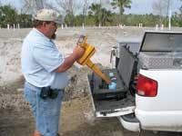
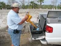
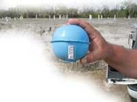
In 2004 Charlotte County adopted a new underground utility marking process that allows it to remotely locate and identify facilities by means of buried markers and remote locators.
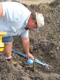
“As we place a new water or sewer line today, marker balls are placed along the pipeline and at each feature and change in the route,” Cain said. “Contractors use a portable marker locator to program important details, such as the pipe type and size, the date it was installed, fitting type, and depth below the surface, into the marker memory just before it goes into the ground. Later, when a locator sends out a search signal, the buried marker responds with stored data, which is displayed on the locator panel. On straight pipeline runs, we place ball markers over the pipe every 150 feet to mark the route. This will give us fast, accurate access to sewer and water lines at any intermediate point.”
According to the Charlotte County utility technician, Florida One-Call crews also place ID marker balls during their routine work locating mains and other buried components. This allows the utility to take advantage of One-Call excavation efforts to record underground details and add new field data to the county’s permanent facilities record as it is collected.
With the marker ball program in place, the next phase of Charlotte County utility construction involves recording of Global Positioning System (GPS) coordinates for each underground marker, Cain said.
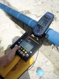
“GPS data entry and management capabilities are included in marker locator software that we already use with the 3M underground ID marker system. The software provides for combining marker information with latitude and longitude values and incorporation into our mapping database,” he said.
Charlotte County uses Geographic Information Systems (GIS) mapping for utility resource management. Information from the ID marker locators is downloaded at the end of each workday and added to the GIS database, reflecting work completed. According to Cain, as GPS data for individual markers is collected in the field, marker longitude and latitude coordinates will be added to a new layer in the GIS mapping database.
Cain notes that GPS data will also be valuable for facilities drawings prepared by the organization’s CAD department. Recorded marker coordinates can be used to auto-create points for the CAD system, resulting in precise and complete as-built drawings.
This paperless, electronic approach to pipeline records will reduce the possibility of error and speed the process of creating and updating CAD pipeline information. He anticipates a 75% reduction in recordkeeping time with GPS input compared to conventional surveys and hand-marking of prints in the field. Field records will include pipe location details as well as full feature attribute data, allowing for rapid search and identification of specified features in particular sections of the water/sewer pipeline network. Predictive and preventive pipeline maintenance work is expected to benefit greatly from this improved level of data accuracy and access.
Cain said the mapping-grade GPS receivers have a positional accuracy of approximately one meter while less costly consumer grade units have a resolution of around three meters. This lower value is sufficient for useful mapping in conjunction with utility markers because once GPS coordinates get the technician close to the marker, a marker locator can pinpoint the buried marker with such accuracy that the ball can be dependably excavated with a post-hole digger.
Cain is currently adopting satellite positioning with the use of inexpensive GPS receivers having sufficient memory to handle the marker data and coordinates and pairing them with 3M marker locator devices. The two devices will communicate in a standard data format by means of an RS-232 connection. In addition to mapping support, this data will be useful for spreadsheet and sortable database applications. Cain expects this new level of detail to improve the efficiency of utility maintenance scheduling and field work.
“For day-to-day maintenance work an operator will be able to scan stored waypoints in the GPS unit to reach the vicinity of a marker of interest and then click on that item to confirm what is at the location,” Cain said. “This will be a useful orientation tool in preparation for digging to reach a pipe or pipe feature or to establish a bearing in order to locate something else.
“With the new GPS-supported underground marking technology, just one person will be able to handle field mapping in a single step during our pipeline infrastructure expansion, placing markers, programming pertinent data in the marker, recording its GPS coordinates, and creating a downloadable record of the day’s work as pipe is laid,” Cain said. “Mapping work will be accomplished on the fly, so there will be no need to return to that location at a later time.”
The demand for new pipeline construction and underground marking in Charlotte County currently takes precedence over marking older, established pipes and pipeline features, and it may be some time before all of the area’s water and sewer facilities are fully marked, Cain said. In the meantime, GPS marker mapping will give maintenance crews the ability to plan ahead, scheduling more time for work to be done in those areas where markers have not yet been placed.
The digital nature of marker and GPS pipeline records will make it possible to frequently update maps that are stored on laptops used in the field by means of wireless or plug-and-sync connections at the end of a shift. In this manner, working crews will have timely access to maps that include details of work done as recently as the previous day.
Cain anticipates that GPS and ID marking will allow utilities such as Charlotte County to more accurately age their underground water and wastewater pipe infrastructure because they have a data/time stamp on every marked location along with the project name and date of construction. This level of detail will help the county conform to government inventory and costing requirements.
“The complexity and value of the County’s underground services continues to grow, with utilities and communication services often sharing limited rights of way,” Cain said. “We need to be able to accurately sort out below-grade structures for maintenance and service additions. Workers in Charlotte County do approximately 2000 locates every month, and this represents 2000 monthly opportunities for water and wastewater pipelines to be hit and damaged. The ID marker and GPS systems will reduce that threat and set the stage for more efficient pipeline management in the future.”
