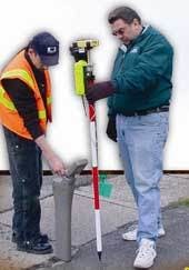
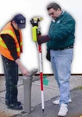
A manufacturer of CCTV pipeline inspection equipment and software will exhibit at WEFTEC ‘07 a new wireless global position system mapping tool that can be used to map municipal assets and produce accurate infrastructure maps.
The Wireless GPS Mapping Stick, available from Cues, is designed to precisely locate structures such as manholes, catch basins, hydrants, etc. and collect sub-meter accurate Global Positioning System (GPS) coordinates for each asset and transmit them seamlessly from a distance of up to 1,500 feet into Cues’ pipeline inspection software called Granite XP.
The GPS data collected in the field by the CCTV crew is associated to the specific asset identified by the crew member and then updated into maps within a Geographic Information System (GIS). When identified in the field, each asset - whether it’s a manhole cover, a lift station or a homeowner’s cleanout - can be given a unique identification number and stored in the GIS database.
The field-based software brings the GPS data back to the office where it can be further validated by a supervisor and/or GIS department for final approval. As more data is accepted and inserted into the relevant GIS layers, the quality of the maps is increased, allowing for data to be shared among other departments and agencies as appropriate. Once captured, the data will make it easier to find specific assets that may have been paved over or buried by debris.
Since CCTV crews spend their time in the field assessing infrastructure, use of the system in conjunction with pipeline inspection has become an efficient method to create accurate GIS maps where none may exist. This new tool can enable CCTV crew members to quickly collect important data during their normal course of inspection work.
Increasing regulatory pressure upon the water industry is forcing system owners to accurately mark the locations of their buried pipelines. The mapping stick can be used to obtain the coordinates of sewer, storm, fiber, and gas pipeline segments, including nodes, main and lateral assets.
The mapping system also can be used to precisely locate where a homeowner’s lateral service connects to the city’s main sewer lines.
As CCTV operators drive their camera tractors down the main sewer lines collecting pipeline assessment data, they can also collect this valuable GPS information as well. Taking this one step further, the Mapping Stick when combined with an electromagnetic sonde locator and a lateral inspection camera can allow operators to trace the path of laterals up to the homeowner’s cleanout if permitted.
Some forward-thinking utility installation firms have used this technology to ensure that their work has not compromised the integrity of the existing wastewater pipelines, including the homeowner’s service connections. The sonde technology can also provide pipeline depth estimates.


