Flying High: How Water Is Adopting Drones

Innovation
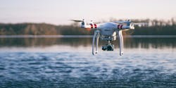
As the popularity of Unmanned Aerial Vehicles (UAVs) - or drones - continues to grow, many organisations across the globe are waking up to the potential of the technology. So, what are the main current and potential applications of drones in water and wastewater treatment facilities?
By Andrew Williams
One of the main current applications for drones is the inspection of assets. In fact, according to Prof. Steve Thomas of the Faculty of Computing, Engineering and Science at the University of South Wales - which has had a long association with Welsh Water and helped the utility to inspect some of its facilities - the emergence of the technology means that some areas are now being “inspected for the first time due to their remote location”.
Meanwhile, New Jersey American Water has created a Small Unmanned Aircraft System (sUAS) program, primarily for the visual inspection of elevated water tanks and inspection of hard to reach areas. This is as well as 2D mapping to enhance its imagery base maps where they are out of date and 3D mapping to monitor construction projects and above ground infrastructure.
As Christopher Kahn, senior GIS project manager at New Jersey American Water, explains, the company currently has six FAA certified pilots, and has obtained a waiver to fly at night. In 2017, it also conducted nearly 200 flights in over 55 locations.
In Kahn’s view, inspection and survey are the “lowest hanging fruit” because they provide immediate benefit and are the simplest to execute. For example, by using drones, he says the company can perform elevated water tower inspections with “more accuracy and less risk, enabling it to inspect all its towers every two years instead of every five years”.
“Safety is our first concern,” he says. “The program is well-structured, with executive oversight and active management. Flight missions are pre-planned, documented, and digitally logged. For inspections, we are able to measure the progression of rust and other conditions, and provide engineers with actionable condition assessments of a larger number of facilities in short order.”
Plant modelling
Elsewhere, Phil Christensen, senior vice president - analytical modelling and reality modelling at Bentley Systems, points out that, like many types of infrastructure, water and wastewater treatment facilities often suffer from incomplete documentation and drawings.
As a result, he argues that the ability to quickly capture an “accurate, engineering-ready 3D model of a plant” helps asset management teams better understand the state of existing facilities, helps maintenance teams inspect and plan maintenance with fewer site visits, and helps engineering teams plan repairs and modifications.
In an effort to foster such capabilities, he also reveals that Real World Capture, a Bentley Systems wholly-owned subsidiary, is currently using drones to capture data as part of its work to create a 3D reality mesh project for Cherokee County Water and Sewerage Authority’s Rose Creek Treatment Facility.
“The plant incorporates sequencing batch reactor technology to meet wastewater discharges of six million gallons per day,” says Christensen. “While the reality capture and modelling project is currently underway, the goal is to capture and build a 3D reality mesh that can then be leveraged during the daily operations of the plant. We plan to integrate asset data sources into the reality mesh and then publish it on a web-based platform that is accessible via a simple web browser.”
Meanwhile, Michal Mazur, partner at PricewaterhouseCoopers (PwC), singles out water quality monitoring as another potential application for drone technology. By using UAVs with infrared cameras, he explains that scientists, employees of water services companies and government officials “have the ability to monitor water areas remotely at a higher spatial resolution than ever before, at low cost and at any time”.
He also points to an interesting project carried out by Australian government state agency the Department of Primary Industries. In 2015 the organisation ran a programme based on drone technologies and image data analytics to monitor the quality of water released into the lower Darling River. Over the course of six months, he reveals that drones successfully controlled the quality of 35,000 mega litres of water released from the Menindee Lakes into the river.
sewer inspection
Another useful application of drones for monitoring water facilities has been found by researchers from Nottingham Trent University. Two years ago, the scientists found that a high-resolution infrared camera could detect from a height the change in soil temperature that occurs when leaking water soaking into underground.”
“This can be used to help reduce the vast quantities of water that may be lost from large-scale underground pipe systems, especially in desert countries where water is transported over large distances,” adds Mazur.
There are also some indications that drones could prove useful for the inspection of sewer networks and collector pipes - with one example being the EU-backed ARSI (Aerial Robot for Sewer Inspection) initiative, a ground breaking project to test the use of a Micro Aerial Vehicle (MAV) for inspection tasks in sewers.
“ARSI keeps the operator in mind and includes a platform design based on multiple state-of-the-art sensors. Today we work mainly on developing inspection tasks to support the on-site workers, but in the near future we will focus on automatic structural inspection, replacing the human eye, and also on hazardous gas detection and sample collection,” says Raúl Hernández, head of the technical department at FCC Environment’s Barcelona & Balearic Islands office.
Culture of safety
In general terms, Kahn observes that improved safety and efficiency, for both employees and customers, are the main drivers for drone use - and Hernández agrees that health and safety at work, and improving working conditions, are key criteria.
“This is a very valuable tool in some critical situations, for example when a sewer system section collapses,” he says.
With appropriate training and practice, Thomas points out that drones are also “relatively easy to pilot” and are becoming “very affordable” as the technology improves rapidly.
However, despite the obvious advantages, Kahn also points to a number of key challenges, including the need to understand regulation and develop a culture of safety, as well as the task of educating organisations about insurance and regulatory implications and communicating the benefits.
“Data and cyber security are also extremely important, and protocols should be put in place with an organisation’s security team,” he says.
Hernández points out that one of the main challenges in carrying out underground inspections is “achieving autonomous flight when a GPS signal is not available, as well as ensuring good quality images in such a hostile atmosphere with no light or humidity”.
“Furthermore, the sewer ducts are usually small in diameter and there are plenty of other obstacles,” he says. “These facts represent a source of turbulence that it’s not easy to manage. However, the continuous research and innovation process that we are engaged in, including testing the equipment on actual working conditions, we hope will provide the necessary feedback to continue our progress.”
Mazur also stresses that one of the chief challenges of using UAVs to monitor water quality is the difficulty of using aerial photogrammetry over water surfaces - particularly since water is “a more dense medium that is always moving” meaning it is “almost impossible” to make ground control points except along a coastline.
“In addition, water penetration and reflectance from the sea bed depend on the sun’s azimuth and elevation angle to the water surface and the sea bed as well as wave propagation. All above factors influence quality of photogrammetry products from water areas, which make the photogrammetry processing much more difficult,” he says.
“However over the time due to technology development we will be able to cut down time and cost necessary to deliver photogrammetry products from water in a similar rate as from land areas,” he adds.
AI Technology
Looking ahead, Kahn believes that Beyond Visual Line of Sight (BVLOS) technology could be the next game changer in the sector and, in five to 10 years predicts that pilots will be able to manage fleets from an office, not on site.
“These fleets will be able to charge and deploy as needed, communicate with Air Traffic Control, perform a myriad of tasks ranging from survey and inspection to surveillance and 3D mapping - all as ordered from a central location, or on a schedule,” he says.
Meanwhile, Thomas points out that specialist cameras such as infrared will become more affordable and may assist with certain applications - and that automation will be the next step for drones – much like driverless cars.
“Following this, AI will be incorporated so that drones will be ‘smart’” he says.
In the near future, Christensen also envisages that water infrastructure owners will build up “digital inventories of their complete set of assets so that every manager, engineer, and maintainer can have on demand access to a detailed 3D model with high resolution photos and also have that model link to existing asset management and maintenance systems”.
Hernández believes that the use of drone technology will not only enhance health and safety conditions, but also lead to clear improvements in the productivity of working teams.
“In the future, drone prototypes will be miniaturized and produced at industrial scale. Research will continue into autonomous navigation, as well as automatizing the post-analysis process,” he says.
Ultimately, Mazur says we will soon witness the further adaptation of drone technologies by water and wastewater treatment facilities in both water quality as well as mapping and inspecting applications. In his view, drones will eventually “replace satellites” to a certain extent and support employees in conducting time-consuming and labour-intensive tasks.
“One of the key innovations will be combining AI with drone technologies by developing deep learning algorithms to automatically perform the inspection of water facilities and water quality monitoring tasks,” he adds.
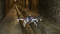
Going underground: One of the main challenges in sub-surface inspections is achieving autonomous flight when a GPS signal is not available
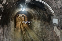
The EU-backed ARSI project tests the use of micro aerial vehicles for inspection tasks in sewers
Andrew Williams is a freelance contributor to WWi magazine.