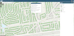
GIS reduces the burden for lead and copper inventory
The U.S. EPA Lead and Copper Rule Revisions (LCRR) requires water suppliers to provide a complete inventory of service lines and develop a lead service line replacement plan.
New requirements, challenging work
The Suffolk County Water Authority (SCWA) utilizes GIS technology to help meet the LCRR requirements. Web-based applications provide an efficient visual database of service line material, allowing SCWA to easily access, track, share, and update their inventory. GIS also enables them to share information with customers.
Prior to implementing GIS, SCWA relied on paper service line records — tap cards — to track service line installations. Storing, retrieving, and updating information was an arduous process. Paper tap cards have been digitized and new tap information was stored electronically in SAP, but there were still challenges identifying data gaps. This made it difficult to create a full service line inventory.Web-based GIS makes data accessible
Utilizing web-based GIS applications, SCWA staff can visually track and edit service line information. They can update material type and indicate how the information was obtained: through public records, institutional knowledge, direct observation, or customers. The integration of the digitized tap cards saved valuable time, as staff could see which homes’ information needed to be updated.
GIS also made it easy to share information with customers. The SCWA website was updated to educate customers about EPA’s LCRR. A web app is used by customers to instantly identify if they have a lead service line. The application also includes an ArcGIS Survey123 form that customers can use to update missing records.The effort to meet the LCRR deadline
To monitor development of the service line inventory, SCWA created a dashboard that enables staff to view real-time progress toward the October 2024 deadline. Staff can quickly filter data and identify problems, such as incorrect data being added to service lines. The ability to quickly see work progress, where records need to be updated, and where lead service lines need to be replaced has enabled SCWA to create an easily understood holistic view of the project. It also enables staff to quickly respond to inquiries or concerns.
SCWA has been able to efficiently maintain its LCRR service line inventory and provide high-quality drinking water to its customers by utilizing GIS.
“Using GIS for our lead service line inventory has been invaluable,” said Christopher Given, deputy director of construction maintenance for the Town of Leesburg, Virginia. “With the ability to access and update inventory data instantly, we have been able to save countless hours and maintain a more accurate and up-to-date inventory. It has improved our efficiency and ultimately enabled us to better serve our customers.” WW
Esri is exhibiting at ACE23, booth #2631. Learn more at www.esri.com.


