Groundwater wells in western Great Basin at risk of high arsenic
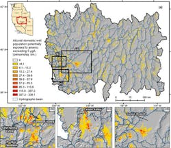
A new study shows that more than 49,000 well users across the drought-stricken western Great Basin may be at risk of exposure to unhealthy levels of arsenic in drinking water, according to a press release by the Desert Research Institute (DRI)
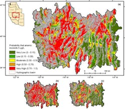
Led by researchers at DRI and the University of Hawai’i Cancer Center and published in Environmental Science and Technology, the study used data from groundwater wells across the western Great Basin to build a model to predict the probability of elevated arsenic in groundwater, and the location and number of private well users at risk.
“What we are finding is that in our region, we have a high probability for elevated arsenic compared to most other regions in the country,” said Daniel Saftner, a hydrogeologist at DRI and lead author of the study. “And we are seeing that geothermal and tectonic processes that are characteristic of the Great Basin contribute to the high concentrations of naturally occurring arsenic in the region’s groundwater.”
“As the arsenic-rich volcanic and meta-sedimentary rocks that form the mountains erode, sediment is transported to the valleys below,” said Steve Bacon, DRI geologist and study co-author. Water percolating through the valley floor then carries arsenic into the groundwater. Deeper, older groundwater and geothermal waters tend to have a higher arsenic concentration and can migrate upward along faults and mix with shallow groundwater.
To train and test the predictive model, the research team used data collected through the Healthy Nevada Project, including water samples from 163 domestic wells primarily located near Reno, Carson City, and Fallon. These data were supplemented with 749 groundwater samples compiled from the USGS National Water Information System. The model uses tectonic, geothermal, geologic, and hydrologic variables to predict the probability of elevated arsenic levels across the region.
Although the U.S. EPA has set an arsenic concentration guideline of 10 µg/L for public drinking water, previous research has shown a range of health effects from long-term exposure to levels above 5 µg/L. Using this concentration as the benchmark, the model and map show that much of the region’s groundwater – particularly in western and central Nevada – is predicted to have more than a 50% probability of elevated arsenic levels.
“Community members can use our arsenic hazard map to see what the risk is at their location, which might motivate them to test their well water,” said Monica Arienzo, Ph.D., associate research professor at DRI and study co-author. “Then, if they have high levels of arsenic or other contaminants, they can take steps to reduce their exposure, such as installing a water treatment system.”
The research team plans to use their model to take a closer look at the health impacts of prolonged arsenic exposure.


