Replacing Lead Service Lines with GIS
The city of Benton Harbor’s water distribution system is more than 100 years old, with many homes built before the 1960s. The water leaving the city’s water plant doesn’t have lead in it — however, many of the water service lines from the property line to the homes are made of lead or have lead components in them, as do some public-side water service lines.
With new funding from the U.S. EPA and the State of Michigan — and a commitment from Governor Gretchen Whitmer — Benton Harbor plans to replace all lead service lines within 18 months.
As the city engineering firm for Benton Harbor, Abonmarche was tasked with coordinating lead service line replacement efforts for a project that would be operating for many months at a breakneck pace.
Abonmarche used Esri’s Lead Service Line Inventory solution as a foundation to support the project’s specific needs and goals. This solution helped to easily set up necessary data layers, maps, and applications — enabling Benton Harbor to go above and beyond to communicate with the community.
“This solution came at the perfect time for us,” said Garrick Garcia, Abonmarche GIS technician. “We wanted something thorough and reliable yet easy to deploy to keep up with the pace of the project. Seeing inspections and construction results in real time is key for monitoring issues as well as sharing results. Recording and publishing work with GIS is a much more efficient process than we would have implemented otherwise.”
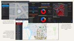
Esri’s Lead Service Line Inventory solution includes built-in maps for use in ArcGIS Field Maps for mobile data collection; Abonmarche staff configured and extended those maps to fit project requirements, then integrated them into the workflow solution. Using the included Project Manager web app, they tracked which service lines have been replaced, have yet to be replaced, and other valuable information. Several custom web applications and dashboards were created, and out-of-the-box solutions were extended so that additional project requirements could be easily managed.
This provided staff with the ability to organize and track Right of Entry forms and feedback received from the community, log mobile work into the GIS, enter service line information into the GIS from the office, track work and categorize it to quantify the results, and share real-time data with the public in an easy-to-digest method.
The Lead Service Line Inventory solution, web applications, and dashboards have changed the face of a critical community health initiative. The solution provided the ability to share accurate, up-to-date information with the public, establishing transparency and building a foundation of trust.
The City of Benton Harbor’s website provides project progress in real time via an easy-to-understand dashboard. It includes a map with the location of each house and two charts showing the materials each service line is made of on the city side and on the customer side. The dashboard also shows the dates and addresses of any recent service line replacements from the past 30 days, offering a valuable monthly snapshot view to the community.
“The Lead Service Line Inventory solution has saved our team and Benton Harbor hundreds of valuable hours that can now be spent in other ways,” Garcia said. “Without using GIS and its accompanying apps and tools, our contractors would be manually filling out forms and sending them to us in bulk; our team would have to then parse through and manually input that data into a spreadsheet to compare with our list of active accounts and manually generate weekly reports of work done.”
Esri’s solutions enable Benton Harbor’s data to be tracked digitally and more accurately in a way that makes sense. The city has eliminated paper updates, transposing information and redundant data entry. Using the new system, information is shared in real time, updates on work completed are shown instantly, and GIS data can be used to autogenerate any needed documentation. WW
Esri is exhibiting at ACE22, booth 17105. Learn more at www.esri.com.
Published in WaterWorld magazine, May 2022.
