Approach to Levee Upgrades Provides Model for Success
By Dan Coleman
Improving the level of flood protection for San Joaquin County communities has taken another step forward with participation by future community areas in the flood planning process. The United States Army Corps of Engineers (USACE) is currently scoping a levee improvement feasibility study for the lower San Joaquin River. Completion of the study requires funding participation by local flood control agencies. In response to the USACE’s local funding requirement, twelve urban San Joaquin County flood control districts entered into an agreement to cooperatively fund the local share. In addition to the urban districts, Reclamation District 2062, a district that currently has less than 10,000 residences but is considered urbanizing, recently joined the ranks of participating agencies in the local cost sharing agreement. By including both urban and urbanizing areas in the process, the communities along the lower San Joaquin River have taken another step beyond other Central Valley areas in bettering the level of flood protection they provide their citizens.
The Tale of Two Rivers
The Great Central Valley of California has two major river systems, the Sacramento River and the San Joaquin River, that transport potential flood waters from the surrounding mountains to the Pacific Ocean. In many ways these river systems, and the communities that face the potential flood risks from each of them, could not be more different. The Sacramento River flows from north to south and, along its lower reach, flows through the economically affluent and influential State Capitol region. The San Joaquin River flows in the opposite direction, from south to north. Along its lower reach the river flows through communities that have experienced severe financial obstacles due in part to the nation’s current economy. Although both rivers, and their respective adjacent communities, face the same potential flood risk, the steps taken by each community to combat the potential flood risk from these two rivers are extremely different.
A Costly Approach
The communities along the lower Sacramento River have been spending millions of dollars studying ways to combat its flood risk for the better part of the last two decades and have begun to construct needed flood control improvements only in the recent past. Seemingly non-ending studies, construction delays and bureaucratic red tape surround the flood protection efforts along the lower Sacramento River. A number of examples of large overhead expenditures on exhaustive studies, as well as projects that have been constructed only to require reconstruction a second, and sometimes a third time, can be found along the Sacramento River system. Levee improvement costs around the Natomas Basin have averaged approximately $12 million per levee mile. In addition to over-costly design, review, and construction procedures, unproductive lawsuits have been filed on behalf of some local flood control agencies against the state. Unfortunately, these tactics have not resulted in improving the local flood control infrastructure but instead have drained more of the state’s resources away from regional flood protection.
Additional projects in the region also carry a large price tag, and although it is important not to assume these project cost numbers represent direct comparisons or correlations on scope of work, they do illustrate the range of projects and enormous expense urban flood control management costs the region and its communities. Examples include:
- Project Title: Bear River North Levee Rehabilitation Project
- Agency: Reclamation District 2103 (Yuba, Sutter and Placer Counties)
- Total Project Cost: $14.7 million
- Project Title: Natomas Levee Improvement Program Early Start Program
- Agency: Sacramento Area Flood Control Agency
- Total Project Cost: $277 million
- Project Title: Feather River Levee Repair Project
- Agency: Three Rivers Levee Improvement Authority (Yuba County and RD 784)
- Total Project Cost: $201.3 million
Community Collaboration
On the other hand, the lower San Joaquin River system presents several project examples that have followed the approach of pragmatic evaluation and timely implementation. The San Joaquin Area Flood Control Agency (SJAFCA) was formed in 1995 as a response to a threat by FEMA to map the greater Stockton Metropolitan area into the 100-year flood plain. The potential flood risks were assessed and mitigated in only three-and-a-half years, and for an average cost of $1.3 million per levee mile and a total design and administration cost of less than 20 percent of the construction costs. In a similar response, and utilizing new, post-Katrina flood risk assessments, the SJAFCA, along with thirteen other reclamation districts and city/county flood control agencies, entered into a cooperative agreement to provide local funding for the USACE to complete its evaluation of the lower San Joaquin River. Many of the local agencies that joined with the SJAFCA didn’t just wait for the USACE to move the project along at a relatively slow pace, but have undertaken substantial flood protection improvements on their own. Reclamation Districts 17 and 2062 are examples of flood protection agencies that have successfully moved from initial project design to construction in as little as one year. This includes the overall construction costs of approximately $2 to $4 million per levee mile and overhead costs that are substantially less than $1 million per mile.
The American Tradition Realized
The traditional “blue collar” work ethic that defines the communities along the lower San Joaquin River has allowed these communities to improve their flood protection status with a “roll up your sleeves” mentality that helped make America great. The bureaucratic quagmire that has come to define Sacramento politics, and is all too representative of the larger national decline, seems to have swallowed the levee improvement projects that the communities along the lower Sacramento River will someday rely upon. Self-reliance, hard work, and efficiency are the cornerstones of a strong community and it is these qualities that have resulted in more flood protection for less money along the lower San Joaquin River and ultimately positioned its community members for a future on safer ground.
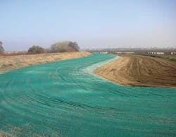
Figure 4: A seepage berm with green hydroseed mix at Reclamation District 17.
A Model for Future Success
As the state faces ongoing flood control issues in other communities, including those along the Feather River, the results of efforts for both the San Joaquin River and the Sacramento River serve as a roadmap for other regions’ involvement in flood control planning and implementation. The issues needn’t be clouded by politics or economics as long as community members work together, become a part of the solution and partner with experts that will move their dollars forward efficiently, not mire them down in costly legal battles, regulatory issues or never-ending studies. Despite the challenges that will arise, the more educated and involved each California community becomes, the more likely it is to be successful in creating its own stable flood control foundation.
About the Author:
Dan Coleman has been part of the geotechnical, environmental and hydrologic engineering industry in California for more than 30 years. He has served a range of clients in the public, institutional and private sectors.
More Urban Water Management Issue Articles


