Mission: Possible: NASA's Global Precipitation Measurement Initiative Aims to Enhance Water Resource Management from Space
By Art Haddaway, WaterWorld Editor
For the first time, a network of satellites will provide instantaneous projections of precipitation every three to four hours over 90 percent of the globe.
Monitoring precipitation patterns via satellites to measure and predict weather events across the globe is nothing new. However, a number of innovative space-based meteorological developments are underway - particularly NASA's Global Precipitation Measurement (GPM) mission - that could potentially change the way industry experts approach water management strategies.
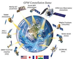
NASA's newly-developed GPM project comprises a network, or "constellation," of nine internationally coordinated satellites that provide highly accurate and advanced precipitation measurements on a global scale from space. Used for a variety of scientific and societal applications, the mission delivers for the first time instantaneous projections of rain and snow patterns every three to four hours over 90 percent of the globe. It also enhances the way precipitation is observed in remote and complex regions of the world, including developing countries where detection is minimal.
"The Earth's freshwater supplies are quite limited, and one of the key measurements required to understand its available waters is precipitation," said Christa Peters-Lidard, a research physical scientist in the Hydrological Sciences Laboratory at NASA's Goddard Space Flight Center. "When you think about the unprecedented advantages of observing precipitation from the vantage point of space, you have unlimited capability to see anywhere on the globe covered by the orbit."
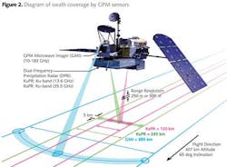
Established in partnership with the Japan Aerospace Exploration Agency (JAXA), NASA's $933-million orbital project serves as an extension of the Tropical Rainfall Measuring Mission (TRMM) launched in 1997 by the two organizations to analyze precipitation cycles within the tropics. Whereas TRMM can only monitor 35 degrees north and south latitudes, GPM can now explore 65 degrees north and south latitudes, covering everything between the Arctic and Antarctic Circles.
The GPM mission serves to increase understanding of water and energy cycles, improve forecasting of extreme events that cause natural disasters, and extend capabilities of using this information to benefit society and the water sector, according to GPM's website. Further, it can enable industry leaders to better quantify hydrologic impacts on their utilities and water resources, potentially leading to improved water conservation, pollution-prevention measures, water treatment methods, energy and cost savings, customer service, and operations.
"For hydrologists, precipitation is always our most important and our first input to the process, and it's a cycle," said Peters-Lidard. "Once you know the input to the system, you can track where it's going and its impacts on other variables that you care about, such as water quality, sediment transport, and water temperature," she said. "By knowing precipitation better, it should help [water managers] model their entire hydrological system better."
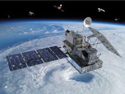
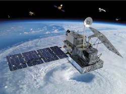
The joint program relies heavily on the GPM Core Observatory Satellite - the foundation of the mission designed to merge and calibrate measurements from every constellation spacecraft and serve as a reference standard for quantifying when, where and how much it rains or snows, according to a Duke University article about the project. The Core launched on Thursday, Feb. 27, from JAXA's Tanegashima Space Center in Japan and will fly at an altitude of 253 miles (407 kilometers) above the Earth in a non-Sun-synchronous orbit as a laboratory to study the fundamentals of precipitation by applying a groundbreaking radar and radiometer system.
Accordingly, the observatory will carry a Dual-frequency Precipitation Radar (DPR) and a multi-channel GPM Microwave Imager (GMI) that will "provide capability to not only measure precipitation but see inside clouds to measure the amount and size of drops, their intensity and type of precipitation," said Peters-Lidard. This system, relative to TRMM's, can better detect light rain and snowfall - "something a lot of the other currently-orbiting satellites cannot do," she said.
Peters-Lidard added that GPM provides the precipitation inputs to other advanced modeling technologies that allow users to simulate how and where precipitation travels once it hits the ground (e.g., infiltration, runoff, evaporation), as well as analyze the way it interacts with and affects the surrounding atmosphere and environment. As such, this can help industry professionals make well-informed decisions about which avenues of their operation - particularly water resource management - to ideally calibrate with those precipitation patterns in order to yield the most lucrative results.
GPM's ability to convey precipitation data in a new timely, accurate and widely extensive manner can, for example, help water or wastewater operators decide what, if any, modifications should be made to their treatment applications or water storage systems. It can also advise experts in the agricultural sector to determine how much water will be available for sufficient crop growth or livestock cultivation. Likewise, it can help municipalities direct their focus toward maintaining infrastructure integrity and improving stormwater management as a whole - ultimately reducing water pollution and improving overall water quality in receiving local waterbodies.
"Timely and accurate precipitation observations provide local decision makers with the information to evaluate freshwater availability and resources within their regions," said Peters-Lidard. "Without this information, the industry would have more uncertainty in their hydrologic analyses, which, in turn, could adversely impact decision making and reliability."
Through NASA's integrated multi-satellite retrieval for GPM (or IMERG), precipitation readings will occur every 30 minutes and offer early (4-hours), late (18 hours) and final (2 months) products after real-time, said Peters-Lidard. She indicated that early data will allow users to forecast short-term events pertaining to floods and landslides, for example, and late statistics will enable them to predict intermediate impacts relating to shortages and droughts, to name a few. Lastly, final analyses provide operators with all consolidated data, allowing them to invest in long-term water resource management, climate studies and other valuable research initiatives.
"Water and wastewater utilities are concerned about the availability of freshwater and about potential events that will stress their systems," said Peters-Lidard. These modeling capabilities not only provide industry leaders with pertinent, time-sensitive rain and snowfall information but also meet both their tactical and strategic operational needs. She added that early and even late calculations focus more on tactical decisions, whereas extended and final estimates concentrate more on strategic decisions. "If they're trying to manage a wastewater utility, they might have to make tactical decisions that deal with short-term flooding or lack of rainfall that might affect how they operate their systems," she said. "Strategic decisions have to do with longer-term water supply. Water and wastewater managers might look to GPM to provide them an update with what has actually fallen within the last two months, and they can get additional information about what has actually occurred over their location using these products and models."
Ana Barros, professor of engineering at Duke University, added that monitoring precipitation is critical to the success of water resource management within the industry today. "From this information, one can assess water scarcity and severity, antecedent conditions leading to extreme events, natural hazards, food production futures, public health conditions, etc.," she said. "Used as input to drive models, it can tell us where and how the water is being stored and how it is moving, and it will allow us to really look at water resources in a more quantitative way."
Duke University, along with the National Oceanic and Atmospheric Administration (NOAA), has partnered with NASA to form the Integrated Precipitation and Hydrology Experiment (IPHEx) - the first field campaign for GPM to be launched this May and June. Serving as a hydrological modeling activity supporting GPM, IPHEx will deploy ground-based gauges and radars as well as several aircraft to obtain additional measurements outlining the many properties of precipitation. IPHEx's website indicates that it will focus on development, evaluation and improvement of remote-sensing precipitation algorithms, giving leaders in the water and wastewater industry more precipitation-monitoring options and capabilities.
"Unique in the sense that it's the first field campaign after the GPM launch, [IPHEx] is a very integrated campaign between meteorology and hydrology," said Barros. "In terms of science, it's an accomplishment because it's hard to get everyone together and study the same thing. We will have all these coordinated observations, meaning that we can actually look at events as they evolve in the atmosphere and propagate them as they move through the natural system."
Certain data products will be available at no cost on NASA's website (http://pmm.nasa.gov) roughly six months after launch, and the more advanced products (IMERG) will be available roughly one year after launch.
About the Author

Art Haddaway
Assistant Editor
Art Haddaway is the Assistant Editor of WaterWorld and Industrial WaterWorld magazines. A writer and editor of over 10 years, he has contributed to a variety of regional publications covering everything from current events to creative features. Art is a graduate of Oral Roberts University in Tulsa, Okla., with a bachelor’s degree in print journalism.
