Project Profile: Technology Transforms St. Johns County Water Utilities
St. Johns County Utilities provides water, sanitary sewer, and reuse water services to 42,000 accounts and 100,000 residents in coastal northeast Florida. This is within dispersed and detached service areas characterized by historic communities, new development, high growth, expansion, and the acquisition of aging private utilities.
St. Johns County Utilities is developing into a medium urban utility with increased expectations. Daily requirements include operating 20 treatment plants, 13 storage tanks, servicing 1,350 miles of distribution and collection mains, capital improvement management, new development review, customer service, and billing.
While keeping standards of cost-effectiveness, prized water quality, and high customer satisfaction, St. Johns County Utilities faced new challenges from expanding capacity, replacing infrastructure, and meeting new regulations for water reuse and availability requirements.
These challenges required a variety of solutions, including mobile solutions that provide key information from centralized services to enable the insight, collaboration, and decision support needed to grow while maintaining cost-effective services. These solutions would transform the way we operate and serve our customers.
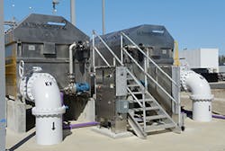
The Northwest Water Reclamation Facility—a modern version of a wastewater treatment plan, but with zero effl uent discharged. All effluent is treated and used for commercial and residential irrigation.
Our solutions were influenced by the success of our existing Cityworks Asset Management Solution. This mobile solution—implemented in partnership with Jones Edmunds and Associates—provides Esri-based map services and integrates the utility infrastructure layers with work order, customer service requests, asset expenditures, and inventory management. This asset management system is used by each treatment plant, warehouse, engineering, billing, and customer service, as well as each of the distribution, lift station, and SCADA field crews using Toughbooks and mobile Wi-Fi. This enables the utility staff to manage preventative maintenance, react quickly towards repairs, and collaborate seamlessly. The impact was increased productivity and a greater thought towards geographic information and mobile technologies in our project approach.
For our new challenges, St. Johns County Utilities focused on several solutions to support our goals, including Esri mobile applications and emergency response tools, an asset condition assessment and capital planning program, advanced hydraulic modeling for system analysis, and fleet logistics tools.
To accomplish these initiatives St. Johns County Utilities teamed with Esri and its partners. Solutions were designed within the five patterns of GIS for water utilities, which includes asset management, planning and analysis, field mobility, operational awareness, and constituent engagement (http://arcg.is/2b7atal).
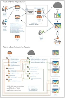
Esri’s ArcGIS Online provided a platform that would reach our mobile users in new ways, connect with our partner agencies, and let us quickly share information with our customers. Web AppBuilder for ArcGIS and Story Map sites (sjcutilitis.maps.arcgis.com), using Esri’s ArcGIS Web Adapter for IIS, are employed to distribute ArcGIS Online products to county staff, contractors, and business partners, providing secure access to the data they need, whenever they need it.
Our first project was very successful in gathering and sharing crucial information about smoke-testing activities for our inflow and infiltration reduction program. ArcGIS Online was used to quickly share the status and results of the testing, keep staff aware, notify homeowners and property managers of testing in their area, and coordinate with contractors and 911 Communication Centers from the Fire and Rescue Department and the Sheriff’s Office. These tools would also be used for public project notices, improvement project updates, water quality, service area, system maps, and—for our contractors—meter replacements and tower site analysis.
ArcGIS Online also provided solutions for our water line breaks, service outages, and “boil water” notices, using tools from Esri’s ArcGIS for Water Utilities for emergency response (http://arcg.is/2aTsKb1). These solutions also help staff investigate and identify water leaks, quickly isolate breaks, perform network traces, and identify affected customers. By partnering with GIS Inc., we were able to quickly configure these and other customized tools, tailor specific configurations, and then release the apps to our staff.
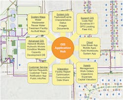
A screenshot of the GIS application’s menu
A condition assessment through GIS-based analysis would best help the utility evaluate aging infrastructure—including acquired deteriorating utilities—and prioritize replacement strategies. A likelihood-of-failure score was derived through GIS analysis of pipe and manhole characteristics—including age, material, diameter, failures, repairs, and rehabilitations—and risk was identified using spatial analysis from soil type, upstream events, and network relationships, along with Cityworks scores for preventative maintenance and inspections.
A consequence-of-failure score was calculated based on the potential impact of a failure—the calculation took into account customer location density, roadways, wetlands, and critical facilities including nursing homes, schools, hospitals, and high-density centers.
Identifying our most at-risk assets through likelihood- and consequence-of-failure scores helps to redefine the capital planning cycle and determine prioritization of inspections, maintenance, repair, rehabilitation, engineering design, and financial projections. St. Johns County Utilities teamed with WK Dickson & Co., to use Esri and Cityworks technology to meet the challenges of becoming a utility of the future.
The engineering division is implementing hydraulic water modeling tools. This shared model provides better understanding of the water network, pressure points, and activities to support decision-making. This model is built on Innovyze’s InfoWater, a GIS integrated water distribution modeling and management software application.
By integrating with our geodatabase model, staff will be able to build a sustainable full-system model, make regular updates, and provide more accurate and complete information of our water system.
The expanded reliance on GIS and these new programs requires dependable and accurate geographic data for analysis, and is the basis of investing in reviewing our workflows; applying industry best practices; and implementing Esri’s ArcGIS Data Reviewer, Task Assistant Manager, and ArcGIS Workflow Manager. Building the quality of our data and streamlining the processes to maintain it, ensure the reliability of our advanced analysis applications.
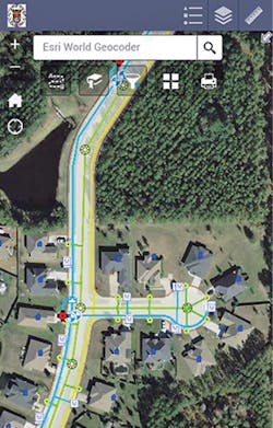
Phone browser system map
Our engineering division has started to use Esri and Cityworks to help streamline capital and development projects through management, scheduling, and inspection tools. Currently, GIS-integrated inspections entail evaluation of manholes and—through our pretreatment program—commercial grease traps. Direct access to the geodatabase through map services saves time and empowers our mobile staff. Our engineering division foresees similar benefits for our mobile staff by managing capital projects overviews and sharing the information with constituents through ArcGIS Online, and for development review and managing project tasks, schedules, and inspections. These solutions also support asset management by helping to identify and record data as it is constructed.
As solutions are implemented, the utility is able to envision GIS tools for other needs. The St. Johns County Utilities Integrated Water Resources Plan (IWRP) anticipates that the service area population will double—to 190,000 residents—by 2040.
The IWRP identifies water resource limitations and the need for alternative water sources—including expanded water reuse systems for irrigation, and reducing water usage through a public conservation awareness program. The utility is considering tools for raising public awareness of water consumption and conservation techniques, along with analysis and design tools to reach our goals of reducing water waste.
St. Johns County Utilities is using GIS and other technology to solve the challenges the utility faces—due to expansion and limited resources—while maintaining quality water products and excellent customer service. This provides a balanced approach that will enable comprehensive and adaptive management to be successful well into the future. Our water utility plans to continue investing in technology that helps to provide reliable and accurate information and supports our commitment to providing high-quality service to our residents. Esri is a valued partner in that commitment to excellence.