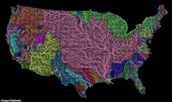
A GIS map of America’s rivers captivated me this week, offering the sort of arresting omniscience that puts entire systems in perspective. I gazed at the map’s colorful capillaries with wonder. To visualize a nation in terms of its interconnected waterways is illuminating.
The San Joaquin River’s path to the sea is a particularly interesting one to trace. The 366-mile long waterway begins as snowmelt in the Sierra Nevada and flows down through mountain canyons to a reservoir at Friant Dam. From there, it is a dry riverbed for much of the year until further down stream, it flows again (thanks to tributaries), eventually feeding into the San Francisco Bay.
Today about half of the water from the river is allowed to flow unimpeded to the ocean for the benefit of fish—most notably, the Delta smelt and the winter-run Chinook salmon. Farmers in the Sacramento Valley rely on the water to irrigate crops, and a number of southern California cities also depend on water funneled from the Sacramento-San Joaquin Delta.
A new draft report from California State Water Control Board explains that the agency is currently considering allowing more water from the San Joaquin and Sacramento rivers to flow out to the Pacific Ocean. The agency is currently analyzing the impact of allowing anywhere from 35 percent to 75 percent of the flows to reach the sea, nourishing fish populations on its way.
The report explains that salmon are a keystone fish species, important to the environment as a food source for native fauna and as enrichment for riverbank soils on the salmon’s upstream migration route.
In an effort to allay concern over the report, water board Chairwoman Felicia Marcus explained that the document is a draft that her agency hopes other groups will comment on before the State Water Board makes a decision next year.
“This is not a proposal to require those flows at all,” she told The East Bay Times. “That is down the line. This is just putting out the science for folks to comment on, so that we can revise it and get it reviewed by more people and have the scientific basis from which we would know what fish and wildlife needs are, and then we balance from there.”
But the draft comes a month after the water board called for a reduction in water withdrawals from the San Joaquin river system. And together, some argue that the two proposals could shift the balance of power in the contentious struggle between cities, farmers, and environmentalists over California’s water supply.
What’s clear is that the water that flows through the Sacramento-San Joaquin River Delta is the lifeblood of the state’s ecosystem, supporting its agriculture, wildlife, economy, and urban populations. But the allocation percentages remain in question, fueling a lively debate. Do you agree with the State Water Board’s proposal to increase the amount of water released for fish?

