When perspectives on sea level rise are considered they might easily take on the glass half-empty or glass half-filled analogy. For many, the glass is half empty and spells doom for thriving municipalities, helplessly sinking into the sea—reminiscent of the cinematic moment in which Charlton Heston finds the Statue of Liberty submerged on the Manhattan shoreline, the outcome of unchecked human folly.
Or, there is the bracing acceptance that climate change and sea level rise is inevitable, but, optimistically as a glass half full, presents an opportunity to exercise ingenuity and rethink our relationship with nature. And for the others, it is a concept best to be avoided—there is no glass at all.
But scientific evidence draws a clear picture of climate change and sea level rise. By projecting the effect to our coastlines and economies on a global scale, it is a scenario to be taken seriously—sooner rather than later. Studies released in May of this year illustrate that five of the Pacific Solomon Islands are lost to sea level rise, having simply disappeared into the ocean.
Hand wringing and waiting is hardly an option, but the glass-half-full contingency has clever innovators who are leveraging technology, collecting data, and harnessing creativity to bring new opportunities, strategic models, and valuable perspectives to coping with the inevitable.
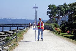
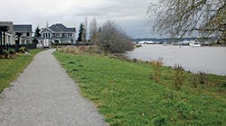
Elgin Village at Nicomekl River during a King Tide event demonstrates the effect of sea rise and the need for preparation.
KEEPING RISK ANALYSIS DYNAMIC
Think of the World Bank. What comes to mind? A huge, inscrutable bureaucracy operating in the ethereal and mysterious world of finance? Decisions made by political heads of state focused on complex and inaccessible issues? A significant initiative directed toward sea level rise and climate change might not be one’s first thought. But Stéphane Hallegatte, senior economist of the World Bank Climate Change Group, affirms, “We’re planning for the long term.”
Hallegatte, who has worked extensively on risk management, adaptation to climate change, urban policy, and green growth, explains that World Bank projects around the world include natural disaster risk management policies and strategies to address climate change mitigation. Another important area is “decision-making under uncertainty”—which might be another way of saying “we don’t know what will happen but if it does, what are our best options?”
“The response to [climate change] threats is really a multi-scale thing. You would have a national response, a regional response, and a very localized response.”
Hallegatte says you could have a small town next to a capital city, but “decision-making done by boundaries doesn’t make sense.”
“You have to really have an analysis of the right scale, but you can benefit by the analysis done by someone else.”
For example, he explains that satellite technology “produced by the United Nations and the European Union (EU), can provide countries in regions such as Sub-saharan Africa, whose other priorities are higher than climate change and sea level rise,” with the data sets to help them manage risks. Accessing the equivalent of a NOAA for information is “virtually nonexistent” for many nations.
But Hallegatte adds that it’s one thing to recognize and address risk, but it is essential to make that process dynamic. “Risk is changing all the time; good risk management is based on constant revision. You cannot assume that you will do the risk analysis and then you’re done forever. In the Netherlands, they redo their risk analysis every five years and this is true everywhere, and for all risks.”
Yet, no matter how ambitious your risk management process is, consideration must be given to the temperament of the people who may be affected by a disaster.
“You have to consider the need for warnings, for evacuations, and you need to be able to convince the populations to respond so that when we say ‘you need to evacuate,’ they will actually do so. There is a delicate balance between fear mongering and informing people to be aware of natural disaster so that they will heed and follow recommendations.”
Hallegatte says that planning for the long term is a central element in the role of the World Bank being responsible in its lending to support infrastructure building in developing countries.
LENDING FOR A LIFETIME OF USE
“A lot of the lending we’re doing is for building things that will last for decades. We’re planning for the long term and this is a central element of what we’re doing. We are also supporting government, local authorities, and providing technical assistance for this long-term planning.”
As senior economist, Hallegatte has developed models of the economic impact of sea level rise that could occur from climate change and subsidence. In his article “Future Flood losses in major coastal cities,” published in Nature, August, 2013, Hallegatte and co-authors Green, Nicholls, Corfee-Morlot offer a sobering glimpse of present and future flood losses in the world’s 136 largest coastal cities. The authors report that average global flood losses in 2005, estimated to be US $6 billion per year, will increase nearly tenfold under the pressures of socioeconomic changes by 2050, to US $52 billion.
The authors report the ironic scenario that as the world’s coastal cities become more dependent on flood defenses, they may reduce their risk of flooding, but without adaptation addressing climate change, sea-level rise, socioeconomic change, and subsidence, they become more at risk to higher losses. In other words, upgraded coastal defenses are not enough. As cities become more dependent on these defenses, protecting more assets, they are also more vulnerable once overtopping or failure occurs. It is this reliance on “infrastructure-based adaptation” that has limitations.
From their research and projections on the cities most vulnerable, those concentrated in the Mediterranean Basin, the Gulf of Mexico, and East Asia, Hallegatte affirms that three important policy conclusions can be drawn.
First, he explains, failing to adapt “is not a viable option in coastal cities,” as adaptation costs could run “a few billion US dollars in initial investment.” Second, maintaining and reducing risk using today’s current standard of coastal flood protection is not enough. Third, improving standards of protection could maintain or reduce risk and decrease the number of floods, however, when floods do occur the “magnitude of losses will still increase,” which authors say “points to the limitations of what infrastructure-based adaptation can achieve.”
“Many cities would experience losses that are more than 50% larger if an event exceeds the post-adaptation protection level.”
The report adds that rich cities are better protected than poorer ones, and the concentration of losses in excess of US $100 million in three American cities—Miami, New York, and New Orleans, account for almost a third of total global aggregate losses due to high wealth and low protection level.
On the other hand, a city like Amsterdam has extremely high exposure, but because its defense standards are the highest in the world, its economic losses are less than US $3 million—a fraction of the others.
While these are projections, the message on the staggering economic losses might be summarized as a directive to see the big picture, even bigger. Subsidence, sea level rise, and increase in population and assets are all crucial factors to consider for future risk. And like Rubik’s cube, when one is changing, it affects the others.
PREPARING FOR UNCERTAINTY AND STRANGE WEATHER
Canadian engineer, Carrie Baron, drainage manager at the city of Surrey, British Columbia (BC), describes how the region is looking at adapting to sea level rise and at the same time coping with subsidence and groundwater intrusion.
Because of their municipal management that is “unlike the lower 48 to the south,” where Federal and state government has oversight, Baron says, “We have local government that is responsible for delivering flood management. We don’t have any Army Corps of Engineers, no FEMA. So, not only do we have land use decisions and flood management decisions, we are responsible for our annual maintenance and inspection. If our flood boxes fail we have to replace them.”
The city of Surrey, just 54 km north of Bellingham, WA, is part of the metropolitan Vancouver region. It is the second largest city in BC and 12th largest in Canada, with nearly half of a million inhabitants. At 122 square miles, Baron says about one-third of the city’s population is sited near the shoreline facing Boundary Bay, a waterway shared by the US that leads out to the Pacific. However, flooding affects 85 of its square kilometers and “In Canada, most residential property cannot get flood insurance.”
Three key goals have been identified to address impacts and increase resilience for Surrey’s infrastructure. First, to deliver proactive climate analysis and management practices for City infrastructure, second to support the design of climate-resilient buildings in Surrey, and finally to advance energy self-sufficiency within the community.
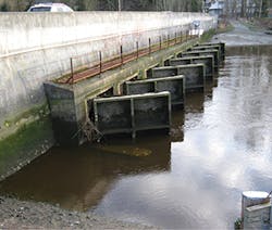
A concrete structure across the Nicomekl River which is equipped with flap gates. The gates are designed to limit the flow of brackish water upstream.
Recognizing that climate change results from greenhouse gas emissions and poses consequences to economies, ecosystems, and social well being, the City has developed award-winning climate adaptation plans.
“Our council has adopted a climate adaptation strategy,” explains Baron, adding that the plan addresses sea level rise and erosion, flooding, and their effects on natural and built environments.
“We also figured out what different temperatures do to street trees, and consider heat stress and emergency watering as we’re experiencing hotter, drier summers and droughts that can impact our agriculture and ecosystems.”
The Surrey Climate Change Strategy has cross-departmental groups who have developed 91 actions to increase resilience in six sectors: Flood Management and Drainage, Infrastructure, Ecosystems and Natural Areas, Urban Trees and Landscaping, Human Health and Safety, and Agriculture and Food Security.
But the plan says taking action is more than “just preparing for uncertainty and stranger weather.” While the geography, population, and assets that are exposed to risk will vary, the plan recognizes that the municipalities that bear the greatest impacts are the ones best situated to respond to (disaster) affected services at the local levels.
“We’ve been doing studies, for example, on rainfall pattern-trending, and we’re trying to regionalize these. There are huge variations in rainfall across Surrey, and even within the areas across the city. We have our data based in real-time monitoring, and then tied to the three gauges which have been the historic guidelines for rainfall. So then, we take all those models, to see what it means to us.
“We can look at studies in variance in rainfall and stormwater, with low-impact development. We don’t have shared pipes; the sanitary and stormwater are separated. All the old stormwater pipes go to the ocean but as we go forward, maybe the answer to servicing is doing it differently. Maybe conveying stormwater on streets instead of pipes so big they never flood is possible, but that’s a huge investment and disruption. I think our whole philosophy to problems must change.”
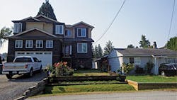
An example of new construction for flood resiliency. The house on the left is a new home adjacent to historic home in the Bridgeview area of Surrey. The front door is at the flood construction level. The garage is not—garages are not habitable and so are allowed to be below FCL. It is almost one story higher than the neighboring house.
According to the Surrey Adaptation Plan, the cost of climate change for Canada is “expected to be CA $21 to $43 billion, or 0.8 to 1% of the GDP per year by 2050,” depending on global efforts to curb emissions, and economic and population growth. But, echoing the World Bank authors, the plan emphasizes that “Adaptation can significantly reduce these costs and is a fiscally prudent measure, given the extent of municipal services affected by climate change.” They define adaptation as the initiatives or measures to reduce the vulnerability of human and natural systems to actual or anticipated effects of climate change.
While the first thought of adaptation might evoke strategies of raising buildings and roads, the Surrey plan includes changing national or provincial standards such as building codes, and developing community by-laws to regulate construction that uses innovation and technologies to capture, store, and convey water, thereby reducing pressure on stormwater systems.
“If you want to build near the coast in a flood plain then we want you to build differently as you are more at risk. We have to require setbacks from slope, and we have to keep agricultural land reserves and have policies that do not allow subdividing which would then prevent natural areas that are intended to flood, not follow their natural course of events.”
Baron also describes the problem of sea level rise and subsidence across clay and peat in the intertidal areas.
“Where we have peat, it breaks down, but clay swells and sinks. So, if you build anything in this area it sinks, but it’s not sinking at the same rate and it’s not natural sinking but man-made. Ultimately, we can’t look just at sea level rise as a stand-alone to those rising levels.”
MAKING NATURAL SOLUTIONS AN ASSET
The Surrey plan makes the distinction that both mitigation “that which takes place to avoid the unmanageable,” and adaption “which aims to manage the unavoidable,” are essential to address climate change.
Current Surrey projects are going toward the use of natural features for new dykes. Baron explains that, “Once we stop fighting nature and not using the hard stuff, there are features that nature then has to deal with such as rocks, logs, strategically placed terraces. We want to preserve our intertidal zone features and we don’t want to lose our coastal habitat.” In assessing the climate impact, the City cites high risk in increased flooding from overtopping of existing sea dykes and more flooding with longer duration with the low-lying floodplains.
By replacing or complementing grey infrastructure with green, resilience can be increased to accommodate extreme precipitation and temperatures but this also improves air quality, lowers energy demand, and offers wildlife a habitat. And this, Baron reports, “then becomes a site for recreational and human enjoyment.”
“We had an old 1950s park, and there was a brick-lined stormwater pipe built into a ditch that ran through the park. So five years ago we did a stormwater study and instead of engineering a new piece of property we went to our Parks people and said ‘can we use part of your parkland for detention?’ and we sweetened the deal by offering to build them a new park. So we moved the playground, collaborated, and we now have beautiful opened pipes, the water is aerated, and the beavers came and there are birds and fish . . . and people just love it.”
Baron says these adaptations and plans are “not just about one department doing one thing but a real cross-departmental partnership that enhances the entire community.”
LOSING GROUND FOR NEARLY 80 YEARS
Two thousand miles to the south of British Columbia is a coast of another kind, where the impact of sea level rise, climate change, and subsidence is on the engineering front burner. In 2005, the devastation of hurricanes Katrina and Rita prompted the Louisiana Legislature to restructure their Wetland Conservation and Restoration Authority, forming the Coastal Protection and Restoration Authority (CPRA). This agency is now charged with the responsibility of developing and implementing coastal protection plans with a Master Plan, revised every five years, and annual project submission plans.
Bren Haase, the agency’s chief of the CPRA Planning and Research Division, offers an overview of their multiple responsibilities. He explains that the Comprehensive Master Plan (CMP) sets the overall priorities to protect Louisiana’s coast with a series of recommended hurricane protection and coastal restoration measures. These emphasize the sustainability of ecosystems, flood protection, and communities. The plan accepts projects submitted by a panel of scientists, federal agency experts, national and international specialists, and other stakeholders whose project recommendations for coastal restoration must conform to the Master Plan (MP) objectives.
“We’re responsible for developing the coastal master plan and we’re also involved in civil work projects, a number of restoration programs, and, we’re heavily involved in projects that work to contain and amend oil spills.” Their objectives also include efforts to reduce annual economic damages.
The list outlines diverse projects in natural areas, such as marshes, barrier islands, oyster reefs, and forest wetlands. But one of the cornerstone efforts that he describes is adding more sediment to the region.
Unlike other water columns who are racing to reduce sediment, Haase says the sediment deficit is a decades-old problem that began in the 30s.
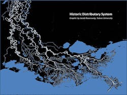
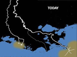
Changes in water channels have resulted in land loss in Louisiana.
“Back then, engineers built levees further up the Mississippi River and this functionally changed the dynamics and retained the sediment further upriver. What we need to do now is to reconnect the upper and lower river and allow sediment to travel unrestricted to this area.
The result of this water channel diversion has resulted in a land-loss crisis. Louisiana has lost nearly 1,900 square miles of land between 1932 to 2010—roughly the size of three Lake Ponchartrains—in just under 80 years. This land loss is the outcome of wetland habitat becoming open water, shorelines that have retreated, and subsidence of dry upland areas. And, the land loss also affects the levels of storm damage.
“As natural protective areas are lost, and levees fail in major storm events, the capital losses increase and this disrupts business, transportation, and communities—crucial components that support Louisiana’s coastal region as a major trade hub.”
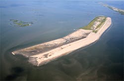
The beginning of construction of the first Shell Island East project (BA-110). The bucket dredge is visible constructing containment dikes on the landward side of the island to contain the beach fill material
A CRABMEAT SHORTAGE?
Land loss has a direct effect on revenue sources derived from coastal shipping and port operations. Studies have estimated that land loss impacts this economic activity at a level of more than $4 billion for Louisiana alone, but these losses affect more than just the local Louisiana coast. Another $3 billion in economic loss affects the rest of the US that relies on this region for its distribution capacity.
“Remember that Louisiana alone is not just the problem area,” says Haase. “What happens on the Louisiana coast also affects the Midwest, as we are the second in volume supplier of shrimp, tuna, crabs, and many other commodities to other parts of the country.”
In order to save these and other assets threatened with economic loss from further devastation, and to conserve the natural environment from the effects of storms, sea level rise, and human interventions such as oil spills, CPRA authorizes Coastal Programs in multiple categories. The new 2017 document builds on the 2012 plan that selected 109 high-performing projects that could substantially increase flood protection for communities and create a sustainable coast.
Completion of the first Shell Island East project (BA-110).
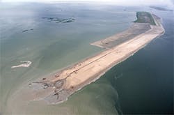
Rebuilding the sediment-deprived barrier islands has been a tremendous success story to that end.
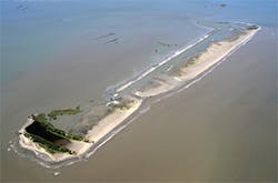
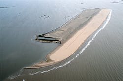
“Since marshlands have turned to open water, rebuilding our barrier islands which are our ‘speedbumps’ in the first line of defense, and then getting sediment back into the lower River.” Haase says that building up the barrier islands is a tremendous success story and the before and after photos are compelling evidence of their transition from land almost devoid of vegetation to one with a verdant and rich landscape.
Prior to the structural intervention that followed the great flood of 1927, the sediment traveled down the river freely through a complex network of tributary outlets, feeding marshes, and wetlands, and deposited at the mouth of the river.
“Over time,” says Hasse, “this builds up the land mass, and like a layer cake, it continues to build up and compacts. Before that time, southwest Louisiana was actually growing at the rate of three quarters of a mile a year. So, based on that process, if there were no upriver levees, we would now have an additional 60 square miles, instead of the deficit we’re facing today.”
Midpoint of construction of the second Shell Island East project (BA-111). In the background, the BA-110 project—constructed in 2013—is visible. The new back-barrier marsh vegetation is visible. The BA-111 project is an extension of the island.
Today, the river has been diverted to a mere few riverine outlets, depriving the marshes of nutrients and stabilizing sediment. “When you have the amount of subsidence we have, plants are vulnerable as they have nothing to adhere to. When a storm surge comes in, they are easily uprooted.”
Haase envisions water being reintroduced to the marshlands through controlled gated levees—a technology
whose design is currently being perfected and will allow for sediment to return and rebuild the marshlands.
SUCCESS IN BRINGING BACK NATURE
Until the levees are ready for prime time, efforts to dredge and pipe in sediment continue, but Haase concedes that this is less sustainable than sediment deposition through natural processes.
“A lot of people talk about coastal erosion but it’s not erosion, it’s subsidence without new mineral sediment—that is the big challenge. And yet, we’ve rebuilt our barrier islands and are continuing that process. They’ve doubled in size and this has direct effect on our environment, and in reducing economic losses. We’re very excited about this progress, and once we can reconnect the upper to the lower River we can rebuild thousands of acres of marshland.” And Haase affirms that one success builds upon another.
Continuance of construction of the second Shell Island East project (BA-111). The sediment pipeline is visible along the island, and fill operations are ongoing at the end of the island on the left side of the frame. The sediment pipeline runs approximately 20 miles to the Mississippi River, where borrow material is being hydraulically dredged.
“We want people to know how successful these projects are and the more people know how our funding has resulted in tremendous gains, the more it increases confidence in supporting the research, the funding, and implementation of crucial restoration efforts.”
With an impressive list of accomplishments since its inception in 2007, many experts believe the CPRA is perhaps the most far reaching and comprehensive restoration effort in the US. To date, it has reported 250 miles of levees that have been built or improved, 25,700 acres of coastal habitat that has benefitted, along with the construction of 45 miles of barrier islands and berms.
More than 150 projects have been moved into design and construction that address multiple Master Plan objectives: structural protection, bank stabilization, oyster barrier reefs, marsh creation, terracing, hydrologic restoration, sediment diversion, and more.
The next Coastal Master Plan for 2017 builds on the current lessons learned and focuses on risk reduction and resilience, communities, and new technologies to advance the state of the art in risk modeling and predictive approaches for protection of the region.
“This is a working coast,” says Haase, “and there is a tremendous amount of activity. It’s not just a place for recreation, we’re at work full time, round the clock, whether its the chemical industry, oil and gas, shipping, and commercial fishing. We need a healthy coast that is resilient and can withstand both man-made and natural disasters. Success for us is also success for the rest of the country.”
For the economies and communities of the Louisiana coastline, the glass is clearly half-full.
In a global study on ocean rise for 24 locations, Dr. Josh Willis and colleagues reported that globally averaged sea level (GSL) rise during the 20th century was significantly higher “than at any time in the past 2,800 years.”
Moreover, the authors found that if “human influence on climate were removed from the record, GSL either would have risen far more slowly or even fallen slightly.
Willis says that this is the evidence that conclusively affirms “something we kind of already knew. But this paper puts the nail in the coffin.”
Researchers used historical data and sophisticated modeling to examine the correlation between GSL and air temperatures and projected sea level rise during the 21st century.Willis observes that for 27 centuries “There is not much going on until the Industrial Revolution, and now, sea level is rising like gangbusters,” he says.
