Restoration Project to Enhance Well Field Wetlands

By David Wiley
Due to a hydraulic connection between the surficial and Upper Floridan aquifers in the Tampa Bay area, creative management techniques are becoming extremely important for minimizing ground-water pumping impacts to wetland features.
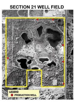
The Section 21 Well Field, currently operated by Tampa Bay Water in Florida, was first developed by the City of St. Petersburg in 1960. It provided the city with potable water supplies for several decades. The field is now part of a regional water supply source for the Tampa Bay area.
The well field property is characterized by lakes and cypress wetlands. Pumping from the six wells at rates of up to 20 mgd has contributed to lowered water levels and depressed hydrologic conditions in lakes and wetlands on the well field property. During the mid 1990's, LBG performed an evaluation of hydrologic conditions in and around the field and concluded that in addition to the drawdown effects from pumpage, there were additional causes for hydrologic stress resulting from drought, drainage, and development.
The effects of the 4-D's (Drought? Drainage? Development? Drawdown) have been found to be prevalent in similar hydrogeologic settings throughout west-central Florida. As a result of these effects, Tampa Bay Water began to look at ways to manage the well field to minimize the pumpage effects.
Well Rehabilitation
At the Section 21 Well Field, the condition and performance characteristics of the production wells were investigated. The evaluation involved the collection of borehole geophysical logs, downhole camera surveys, and pumping tests. Borehole geophysics were used to confirm well construction dimensions, physical properties of the aquifer formation material, chemical characteristics of local groundwater and flow characteristics of the boreholes.
Downhole video camera surveys were performed to evaluate the condition of the casing and identify locations of apparent secondary porosity within the Upper Floridan aquifer. Pumping tests were performed to determine hydraulic properties of the aquifer and/or specific capacities of the wells.
Results of the investigation produced a number of findings. Most wells were similar in construction to that originally reported. Well casings were covered with bacteria and scale. A clay or clayey semi-confining layer was interpreted from geophysical logs to be present at some of the well locations. The video surveys revealed that horizontal and vertical fracturing exists in all boreholes. The geophysical logs indicated that flow in the boreholes was primarily upward. The investigation also revealed that there are two primary production zones in the aquifer system at the well field area.
To minimize impacts on the lakes and wetlands, it was recommended that the existing production wells be modified. The modifications included lengthening the well casings by installing liners and deepening the wells.
Restoration
In association with HDR Engineering, LBG is currently working on the restoration study, which is sponsored by Tampa Bay Water, the Southwest Florida Water Management District (SWFWMD), and the U.S. Environmental Protection Agency. The initial phase includes a public health risk assessment to evaluate the feasibility of restoring the surficial system with surface water from a stormwater canal or reclaimed water from an advanced wastewater treatment plant. Health risks are of key importance because the groundwater resource is used for potable supply.

Several field tests have been performed to gain a better understanding of the local hydrogeologic system. Surface geophysics were conducted using ground-penetrating radar (GPR) to assist in identification of sub-surface conditions. Of particular interest were discontinuities in the clay confining layers and karst related features such as sinkholes. Information obtained from the GPR survey and other available hydrogeologic information was then used to assist in determining locations for coring activities. Over 30 soil borings were made with undisturbed soil cores collected to analyze vertical permeability.
Aquifer testing was performed to estimate average values for aquifer characteristics. A tracer test was conducted during the aquifer test using a sodium chloride tracer. The tracer test was used to estimate porosity and dispersivity of the aquifer. A tracer test was also performed within a wetland to estimate porosity and dispersivity of the sediments beneath the wetland. Slug tests were performed in monitor wells to estimate characteristics of the surficial aquifer.
Computer Modeling
A ground-water flow model using MODFLOW was developed to simulate the flow system. A five-layer model was developed based on geologic information derived from the boring program. The model was calibrated to water levels measured in 17 wells across the site. The calibrated model was then used to simulate the effect of restoration of wetlands and lakes on the site.
The particle-tracking model MODPATH was used to track the movement and travel times of the simulated particles from the receiving wetlands and lakes to the production wells. The solute-transport model MT3D was used to estimate the effect of dilution and dispersion on the concentration of a parameter in the restoration water during movement through the ground-water system.
Water samples were collected from the monitoring wells, lakes, and the potential sources of restoration water. The water-quality analysis results will be used together with the results of the ground-water flow and transport modeling to perform a risk analysis for the use of surface water and reclaimed water for restoration of wetlands and lakes.
Upon completion of the well rehabilitation, the ground-water model will be revised to assess the potential effects of the restoration project. The results of the well rehabilitation and restoration activities should provide an important component for the overall management of water resources at the Section 21 Well Field. Water levels in wetland features should improve as a result of these efforts.
About the Author:
David A. Wiley, PE, is a principal and head of the Tampa office of Leggette Brashears & Graham, Inc. (LBG), a national groundwater and environmental engineering services firm. He has over 20 years of professional experience in all phases of project management, hydrogeologic evaluations for water resource projects, water supply development, well rehabilitation, water use permitting, computer modeling, contamination assessment, environmental assessments, surface water studies, aquifer storage and recovery, and mine dewatering projects.