Sand extraction finances innovative stormwater treatment project in Australia
By Tim Fisher, Leigh Street
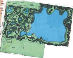
An innovative program, financed by valuable sand reserves extracted for building and construction use, converted a long-neglected site used largely for hard-waste collection in the southeastern suburbs of Melbourne, Australia into an environmental and community asset. The newly created Karkarook Park features a 16-ha lake and a 9.5-ha wetland system that functions as a storm detention system.
Parks Victoria contracted the Australian company CSR in joint venture with Boral, to extract the sand and redevelop the site to provide passive recreation with environmental benefits. The international consultancy URS served as the principal consultant for the project by providing engineering design and project management services.
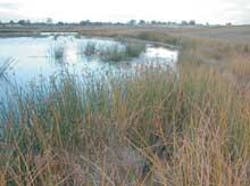
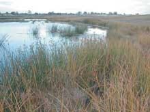
The removal of sand and controlled landscaping and significant hydraulic infrastructure helped create the wetland system, which functions as a stormwater treatment facility. Pollutant traps located at the head of the wetlands capture sediment, litter and oil. Varying bathymetry, hydraulic control structures and a diverse vegetation system removes nitrogen, phosphorous, suspended solids and other contaminants.
The earthworks included three major stages: wetland system, requiring the excavation of 200,000 cubic meters (m3) for use as landfill and a small amount of sand extraction; lake area, involving two million tons of sand extraction, 50,000 m3 of topsoil moved and an additional 20,000 reused on site, and 200,000 m3 removed and used for lake construction; and rehabilitation and landscape earthworks.
The works conducted for the lake involved approximately 150,000 m3 of material that was cut and filled on the project, forming batters, the base of the lake, and wetland areas. A rock retaining wall more than 800-m-long was constructed along the southern wing of the site. The wall eliminates erosion from the wave action of the lake, which is encircled by 2,500 m of asphalt pathways that provide access to most areas of the park.
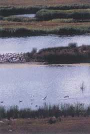
Three timber structures, two viewing platforms and a bridge constructed at different points around the lake provide vantage points for sightseeing and bird watching. A small shed contains a compressor unit that pumps air into the lake, preventing stratification of the lake water. Final works included the installation of timber bollards, grass seeding, topsoiling, and planting out of selected zones above the water line with a range of indigenous species. Lake margins were designed with a predominance of ephemeral, shallow and deep marsh zones to encourage growth of a healthy ecosystem.
The project demonstrated a significant achievement in recycling and reuse. Materials that were reused at Karkarook Park included topsoil and overburden resources. Most of the overburden from the lake went back into the lake progressively throughout the extraction process. More than 40 percent of the topsoil was reused at the site for landscaping and the remainder was offered to the commercial landscaping market.
The advantages of retaining the original topsoil included minimising the introduction of exotic plant species and planting trees that are indigenous to the area. A hydraulic sluicing method minimised dust pollution and energy use. The 1.4 million litres of water used in that process is recycled on-site by conveying sand to the processing plant and washing sand during the production process.
Groundwater, both perched and from aquifers, presented a major problem, particularly when combined with fine high-plasticity sands. As a consequence, shifting earth around the site became difficult, with machinery becoming bogged down in spots and areas of the project becoming inaccessible. The risk of construction material overturning on the steep, unstable terrain was a source of concern. The problem of saturated ground was resolved by catching and directing the water, using subsoil drainage, French drains and cement stabilisation of the sub grades under pavements. Approximately 700 m of subsoil drainage more than one metre deep was placed around the site to dry out wet areas. A combination of haul roads and benching of the site alleviated the risk of machinery rolling over.
Erosion of the predominantly sandy soil, a major challenge identified during design, was mitigated through several measures. These included the construction of a complex network of earth drains around the site, designed to catch the water and direct it into rock-lined batter drains from the six hectares of exposed batters (slopes). Other techniques included the construction of spoon drains around the asphalt paths, which directed water into 79 pits constructed in situ, controlling water flow to the lake with approximately 800 m of underground drains.
Water pumped from an aquifer 120 m deep located about one kilometre away filled the lake. Erosion in the outfall area from the pump is being controlled by rock beaching, using 300-diameter rock to line the subgrade, and a blend of 75-mm base course and 20-mm aggregate to fill the voids.
The completed lake and wetland function as a one-in-100-year storm detention system to alleviate overloading on the downstream drainage system. The 500-ha catchment delivers about 36 m3 per second of inflow during a 100-year event. The design criteria required that the lake was not to receive any stormwater except when flows exceeded those from a one-in-10-year event. The wetland had to store that quantity independent of the lake so an overflow and outlet control system was developed to meet that requirement.
An assessment of the drainage system base flow determined the viability of the wetland during prolonged dry periods and water quality of both base flows and storm flows. This was used to predict wetland performance and to see whether any stormwater could be used for filling the lake. Given the stringent water quality parameters, the source of water used for filling the lake had to be checked thoroughly.
Interaction with the groundwater system had to be gauged since the lake and wetland were to be sited 12 m below ground level. The intent was to determine whether the lake would retain water and whether the lake would have an impact on the groundwater or vice versa.
URS began an extensive groundwater investigation by assessing three aquifers. Water quality parameters were obtained along with water elevations over a number of locations. Groundwater flows were modelled for a range of project scenarios. It was concluded that the water for the lake could be sourced from the Silurian aquifer at a depth of 120 m below the surface. The water quality in terms of nutrients and TDS within the aquifer far exceeded the water quality in the shallower systems. Pump tests revealed that a single bore could fill the lake in one and a half years, a volume of 630,000 m3.
A series of models was established and run to simulate a period of up to 75 years to ensure that lake water quality remained satisfactory over the life of the lake. Evaporative losses in the lake would exceed inflow from rainfall and cause an increase in salt levels (TDS). To counter that possibility, regular input from the groundwater system is needed over the life of the lake. The critical levels of nitrogen and phosphate also were checked and, based on the requirement to input water each year, these levels were forecast to stabilise in the long term.
Deep bodies of water often suffer from stratification, which can lead to anaerobic conditions in the bottom of the lake and severe declines in the water quality through the release of metals and nutrients from the lake bed. As a preventive measure, a bubble plume aerator was designed in the system. The system that was specified automatically detects adverse changes in dissolved oxygen and temperature and initiates de-stratification.
The design of the lake and wetland maximises the use of the sand resource, providing for the proper function of the detention basin and wetland systems while meeting the criteria of parkland amenities. Toward that end, a detailed three-dimensional digital terrain model was used in the design documentation. In addition, the nature of the soil on the site required that the stability of all slopes be given special attention during the design and construction phases. Appropriate lining and extensive surface drainage systems protect the highly erosive clay sand.
The surrounding community was actively involved in the design and development of Karkarook Park from its inception. Local school groups also contributed by conducting environmental studies of the frog population and the quality of the water. A traffic management plan controlled the flow of traffic to and from the site as well as changes in access to neighbouring areas. The Karkarook Park project illustrates how business, government, the community, and the environment can all profit through the sensible management of natural assets.
Authors' noteBased in Richmond, Australia, Tim Fisher is the principal civil engineer for URS Corporation. Leigh Street is the business development manager at CSR Readymix, based in Melbourne, Australia.


