Virtual construction and geospatial technologies reduce risk and costs in design-build projects
By John Stenmark
Like many older cities in the U.S., Washington, D.C.’s sewer system collects sanitary sewage and stormwater into common pipes that carry water to a treatment plant. A popular tourist destination, Washington also has a large commuter workforce that creates demand for water and sewer services.
But people aren’t the only source of high demand: Weather and aging infrastructure can create a huge challenge for the city’s sewer system, which dates back to the early 1800s. During heavy rains, the runoff exceeds the system’s treatment capacity. These combined sewer overflow (CSO) events result in the release of untreated effluent into area rivers.
To help mitigate the problem, the District of Columbia Water & Sewer Authority (DC Water) is building a series of massive tunnels that will capture and store runoff, then feed the water to treatment plants in a controlled flow. The tunnels ultimately connect to the Blue Plains Advanced Wastewater Treatment Plant where a new pumping station will lift the water from the tunnels and deliver it to the treatment facilities.
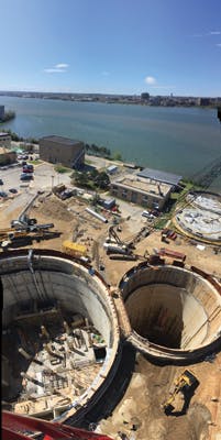
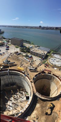
The tunnel into the Blue Plains plant is 5 miles (8 km) long, 23 feet (7 m) in diameter and roughly 170 feet (52 m) below the surface. It connects to a pair of circular concrete shafts 132 feet (40 m) in diameter that will contain the massive piping, pumps and equipment that make up the tunnel dewatering pump station (TDPS). The joint venture of PC Construction (PC) and CDM Smith has a design-build contract on the pumping station and related facilities.
The project is similar to placing a 12-story industrial facility with seven levels of steel, mechanical and electrical components into a deep, round hole, said Abe Torres, a senior engineer with PC Construction. The design and construction of such a complex facility is a prime opportunity to leverage building information modeling (BIM) with spatial technologies to maximize efficiency and reduce costs.
PC Construction engineer Abe Torres likened the project to placing a 12-story industrial facility with seven levels of steel, mechanical and electrical components into a deep, round hole.
3D Scanning Reduces Worktime
When Torres arrived on the project, another firm had already completed construction on the two shafts. The shafts’ concrete liners included beam pockets and keyways to support the new structures. PC needed to verify the dimensions and locations of these and compare them to the 3D model of the concrete structure that they would build into the shaft. Torres suggested 3D scanning as a fast, cost-effective approach.
Using a Trimble® TX5 scanner, PC crews scanned the first shaft. After registering the scans to produce a single point cloud in Trimble RealWorks software, Torres could bring in the design model.
Using the scanning data, the design team merged field measurements with the 3D design model of the pump station. “We had to turn it a little bit, not much,” Torres said. “With the exact dimensions in hand, we figured out that we could prefabricate our beams and steel. Crews can do much of the assembly outside and then slide it into the hole and put it in place.”
The second shaft came with challenges. Scanning revealed that the concrete liner was out of plumb in places and that the design would need adjustments. “Our rebar was going to be too long,” Torres explained. “Had we ordered rebar according to the original design, there was no way it would fit. Doing the scan and checking it against the model saved us a lot of money.”
Checking the models and feeding up-to-date information to construction crews is a continuous process. Matt Harraka, a virtual design construction manager for CDM Smith, noted that engineers and designers use a broad range of software tools to develop structural, architectural, MEP (mechanical, electrical and plumbing) and grading designs. Harraka manages different file formats to bring the designs together in large model viewer systems such as Navisworks or — for earthworks and surveying — Trimble Business Center software.
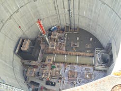
Installation of large components (the pipe is 13 feet in diameter) relied on precise measurements and accurate modeling. Scans of shaft walls captured beam pockets and keyways for future floors.
PC uses Trimble Connect to manage and share design and construction documents with field engineers and subcontractors. As design changes occur, Torres uses Tekla software to manage the model and check for fit or clashes, placing updated files onto the Trimble Connect server. Then the data goes to handheld field controllers for layout.
The choice of field software depends on the task. PC crews use Trimble Access™ software for all the surveying work and control. Layout and inspection for site grading is done using Trimble SCS900 Site Controller Software and engineers and tradesmen use Trimble Field Link software and total stations for layout inside the shaft.
Keeping and using an accurate model is an essential part of quality control. Any design changes can be double-checked against existing conditions before going to the field. The extensive checking means that errors are avoided, while cloud-based file sharing ensures that everyone is using the same plans. Everything in the pump station — from concrete structures to ductwork — goes through the modeling and review processes. “If it’s not in the model, then it’s not going to be laid out in the field,” Torres said.
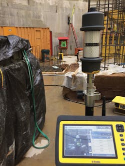
A PC surveyor is shown on the Yuma display. The surveyor is seen from the total station mounted on a bracket on the shaft wall (above the red ladder.)
Adopting New Technologies
The company’s effort to integrate BIM with field work encountered some challenges, noted Ron Ellison, PC chief field engineer. “The big challenge for us was how to get this 3D model into the field.”
New generations of workers are readily adopting these approaches, but Ellison said that even seasoned workers recognize the value of 3D models in the field. It enables them to visualize the components of the project they are working on and see the relationship to yet-to-be-constructed aspects. Prior to concrete pours, PC workers can verify that forms and rebar are positioned correctly. Construction workers use the models to install MEP and other components.
Ellison develops site information and constructible models from design documents and sends them to the field for layout, excavation and grading. “We’re seeing 30 percent savings, maybe more, compared to what I call the old-school 2D way,” Ellison said. “Having a model means it’s set up, checked and ready to go.”
Preventing Problems
The ability to measure and plan in detail delivered big benefits. One example is the installation of a large header pipe needed to deliver water to the pumping equipment. The steel header is 13 feet (4 m) in diameter and runs the width of the shaft. PC rented a special crane to handle the pipe. “We had just two days to put everything together,” Torres said. “We worked with zero tolerance, because the pipe is so big and heavy that if we had needed to move it then it would probably have broken all the anchor bolts, which would have been a disastrous setback. Everything was thoroughly planned, checked and re-checked.” The rigorous measurement and checking enabled installation to move according to plan.
“That’s our biggest benefit: to catch and eliminate mistakes in the office before they get to the field,” Ellison said.
Harraka pointed to recent graduates emerging from trade schools and colleges as an enabling force for BIM and virtual construction technologies. As we go forward there’s going to be more tech-savvy people. This can do nothing but grow.” WW
John Stenmark is a writer and consultant who has more than two decades experience working in the architecture/engineering/construction and technical industries.
Circle No. 241 on Reader Service Card


