GIS study locates groundwater in arid regions
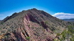
A collaborative team of researchers from Australia, Egypt and Saudi Arabia, have used Australia’s Flinders Ranges to demonstrate how precious groundwater can be found without expensive drilling.
Combining satellite imagery and geospatial techniques with preexisting information on drainage, rock types, fractures, topography and rainfall, the team mapped the Hawker region of the mountain range into three distinct classifications for groundwater stored in fractured rock aquifers: good, moderate and low.
The study indicates that the most effective groundwater recharge zones (where surface water collects as it moves downwards) are located where there are numerous rock fractures, low drainage and a gentle slope. Conversely, the least effective areas to find groundwater are underlain by shale and siltstone.
“The remote sensing doesn’t cost us anything because existing satellites located above Australia are already taking photos of the topography. We also have the software – GIS – to analyze and map all the data,” says University of South Australia researcher Alaa Ahmed.
Existing methods to assess groundwater sources involve extensive drilling, which is expensive, time consuming and often inaccurate. Using a combination of remote sensing, GIS and information and other geological factors, hydrologists may be able to find precise groundwater locations at a fraction of the cost, he says.
Groundwater is the main source of fresh water in the Australia’s Flinders Ranges region and is affected by the type, thickness and structural fabric of the underlying rocks, erosion, topography, drainage and the climate.
While this study was undertaken in South Australia, the team says that the same techniques could be used to detect groundwater in any arid region across the world.
“It will enable policymakers to decide potential sites for recharging the groundwater aquifers without depleting or harming the environment,” says Ahmed.
The study has been published in the journal Water.