Community Mitigates Flooding Issues with Holistic Approach

By Matt Manges
Founded as a sugar plantation in the early 20th century and incorporated in 1959, the City of Sugar Land is the economic center of Fort Bend County in Texas. In the early 1970s, as the city expanded, a new subdivision development called Covington Woods was constructed. Over the next few decades, Sugar Land continued its rapid residential and commercial growth, becoming one of the most affluent cities in the state. Between 2000 and 2010, the city grew a whopping 158 percent, according to census data.
As a result, the Covington Woods region is mostly developed with very little open property. Every year, the region is hit by intense thunderstorms with an annual rainfall of approximately 50 inches. Additionally, the drainage infrastructure was developed prior to current development criteria and is in need of updating. With an almost entirely flat topography, the region has historically faced drainage problems due to varying storm sewer capacity issues and inadequate overland sheet flow paths.
Over the last decade, forward-thinking leaders at the city have been making substantial progress to reduce these flooding issues. In 2007, the city adopted its first Master Drainage Plan (MDP) that established criteria for evaluating, scoring and ranking drainage problems. From 2009 to 2011, the city proceeded to develop its integrated stormwater management model utilizing GIS and LIDAR data and InfoWorks to generate a high-level, city-wide model that would provide a starting point for identification of hot spots within the drainage system that would need further investigation. In 2013, the city hired Lockwood, Andrews & Newnam Inc. (LAN), a national civil engineering firm based in Houston, to study the Covington Woods region as a whole, including its interaction with other interconnecting drainage systems, and recommend future drainage improvements.
“Previous studies and improvements within the Covington Woods region studied selected portions of the region or attempted to address sub‐regional issues,” said Chris Steubing, P.E., C.F.M., assistant city manager at City of Sugar Land. “Through this study, we wanted a comprehensive understanding of the limitations and deficiencies of the various drainage systems, and to determine region-wide improvements that are efficient, cost-effective and support the MDP.”
Existing Conditions Analysis
Subsequently, LAN performed an exhaustive drainage and conveyance analysis of the region. The study area, which included a mixture of residential and commercial areas located in the northern portion of Sugar Land, encompassed more than 1,900 acres of drainage area, 30 miles of storm sewer and over 800 inlets.
The project team developed detailed two‐dimensional models with InfoWorks ICM to understand the complex drainage issues observed within the region. Two‐dimensional models offer unique insight into how overland stormwater conveyance is tightly coupled to and influenced by the subsurface storm sewer system. The performance of the stormwater infrastructure within the region was evaluated for the 100‐, 25‐, 10‐, 5‐, and 2‐year 24‐hour storm events.
The analysis showed that the region’s stormwater infrastructure was functionally insufficient in several locations per MDP criteria. In general, the region was subject to widespread roadway inundation during the 100‐, 25‐, and 10‐year 24‐hour events. Many of the roadways within the region were impassable during lesser events and subject to excessively long drain durations. The neighborhood was also subject to a series of cascading system overflows starting at the northern end of the neighborhood and continuing to the southeastern corner where it consolidated before draining through storm sewer systems to Covington Woods Ditch. The cascading overflows do not enter an outfall channel via overland means, aggregate in low elevation areas, and rely on storm sewers to complete drain. Additionally, Covington Woods Ditch is effectively located at a regional high point and as such, topography controls the maximum water surface elevations within the Covington Woods ditch.
Proposed Improvements
Following the analysis, the project team proposed a series of drainage improvement projects developed in accordance with the city’s infrastructure design criteria, MDP, and the desire to meet as much of the current design criteria as possible. The improvement projects were evaluated on a number of factors including: the project’s dependence on other projects or phasing to operate; critical roadways removed from flooding; reduction in ponding duration; and reduction in ponding extents. The most beneficial improvement projects that served as the “backbone” for other future improvements were given the highest priority.
“Two types of drainage improvements are usually considered when attempting to improve drainage within a region: stormwater conveyance or detention improvements,” said Derek St. John, P.E, LAN’s vice president. “In the case of the Covington Woods region, we proposed both types of improvement options. We suggested storm sewer improvements at various locations to move stormwater out of neighborhoods and downstream to the region’s outfall. More importantly, we also recommended detention improvements to offset potential downstream impacts of these conveyance improvements.”
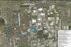
The project team estimated that the proposed improvements, once implemented, would drastically reduce ponding extents, depths and durations. In addition to reducing the overall ponded area, the proposed improvements reduced excessive flooding durations. Inundated roadways with excessively long ponding durations would also drain significantly faster from these improvements. Following LAN’s recommendations, the city identified a total of 10 improvement projects in its drainage Capital Improvements Program (CIP), as shown in the map. They included:
- Covington Woods offline pond improvement project
- A-22 Bournewood trunk line
- Jess Pirtle bridge improvements and business park ditch interconnect
- Jess Pirtle side streets
- Ivymount improvements
- Greywood improvements
- Sugar Land Middle School and Sugar Mill relief line
- Greenway improvements
- Covington West and Imperial Woods
- Sugar Mill north of A-22 improvements
Off-Line Pond Conversion
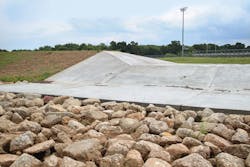
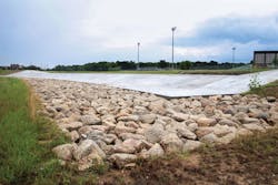
The Covington Woods offline pond improvement project was ranked as the highest priority project by the city due to its mitigation of downstream impacts. The existing 17-acre detention basin operated as a flow-through basin such that its storage levels and volume were driven solely by the channel water surface elevations. The project team converted the western portion of the detention basin to an “offline” detention basin where the detention level and volume are controlled by a weir inlet structure. The advantage of the offline detention facility with weir control structure is that storage can be reserved for later in the storm event in order to capture the peak flow of the channel.
The western portion of the existing basin was excavated to lower storage elevations while providing an overall increase in effective storage volume. The excavated material was then used to construct a berm along the newly established offline basin adjacent to the channel. As part of the berm construction, a weir was constructed in order to control flow into and out of the detention basin. An additional low-flow outfall structure was also constructed to fully drain the pond once the storm peak receded. This low-flow outfall structure included a back-flow device to prevent channel water surface elevations from backfilling the detention basin ahead of the weir control structure coming into operation. In tandem with the weir control structure, modifications to the existing control culvert structures located west of the existing detention basin were also included. These improvements expanded the storage capacity of the basin and mitigated potential downstream impacts from other projects scheduled to be implemented in future phases.
“We took an existing city-owned property in a highly-developed area, expanded it for a greatly reduced cost compared to an entirely new basin, and were able to mitigate downstream improvements at the same time,” said St. John.
Conclusion
Thanks to these improvements, the city is well on its way to solving the flooding issues in the Covington Woods region. The off-line pond improvement project was completed in December 2016. The A-22 Bournewood trunk line is currently under construction. The city is phasing the other projects over a number of years and several are currently under various stages of design and construction. The city’s holistic approach is an excellent example of how flood risks can be reduced cost-effectively while planning for future growth and development at the same time.
“We are continuing to be good stewards for our community,” said Steubing. “The fact that the city is growing rapidly is wonderful. But with that growth, we need to improve our infrastructure in an efficient, cost-effective manner. The drainage projects at Covington Woods are an important component of that improvement.”
About the Author: Matt Manges, P.E., C.F.M., is a team leader and regional stormwater manager at Lockwood, Andrews & Newnam Inc., a national civil engineering firm. He can be reached at [email protected].