Reconditioning of Site Soils For an LID Design
By Carter Hubbard, Ashley Buckwalter and Ben Higgins
Sustainable design and low impact development (LID) practices are becoming more common across the United States. Diverse cities such as Seattle, WA, Santa Monica, CA, and Sherwood, AR, have found great success, both environmentally and economically, by implementing low impact design. Successes in these communities created a desire to investigate LID design concepts to determine whether they could be adapted to the local soils, topography, and climate of Lincoln, NE.
Local soils are a major challenge to incorporation of LID design. Southeastern Nebraska soils are comprised largely of fine silts and clays, which have very low permeability and high runoff potential. Because infiltration is a primary component of LID design, engineers were forced to think outside the box to come up with a solution that was economical as well as practical.
Site Design
In order to examine the feasibility of implementing LID strategies in Lincoln, engineers took an existing conventional residential development and created a hypothetical redesign using LID concepts for stormwater management.
The site chosen for the hypothetical LID design and analysis is located in southeast Lincoln. The site is approximately 52 acres in size and is located along the divide between two watersheds. The hypothetical redevelopment of the site was designed to minimize mass grading of the site and provide lot, street, and drainageway layouts that conform to the pre-existing contours of the site. Roads through the development were narrowed to provide less pervious surface. In addition, the roadways were designed to incorporate vegetated medians and vegetated or permeable parking areas, which would also serve as infiltration features.
Soil Characteristics
According to the USDA-NCSS Web Soil Survey, predevelopment soils in the watershed generally consist of the Wymore and Sharpsburg associations. Wymore and Sharpsburg soils are defined as silty clay or silty clay loam, falling into Hydrologic Soil Group (HSG) “D” and HSG “B,” respectively. Although the HSG classifications for the soils are different, their particle size distributions are remarkably similar. The key difference is the permeability of the surface (0-1 ft. deep) and subsoil (1-4 ft. deep) layers. Wymore soils have surface and subsoil layers with relatively low permeability, leading to their classification as HSG “D” soils.
In order to determine whether infiltration trenches could be constructed using the existing site soils, soil samples were obtained to identify precise soil permeability. Based on the results of falling head percolation tests, the minimum saturated hydraulic conductivity for the least permeable soil layer at the site is ~0.01 in/hr. According to the Mid-America Regional Council and American Public Works Association (MARC-APWA), soils surrounding infiltration features should have a minimum permeability rate of 0.5 in/hr. Since the hydraulic conductivity of the soils at the site is significantly lower than the recommended minimum permeability rate, the soils at the site would require reconditioning before they could be used around infiltration features.
Soil Reconditioning
Using minimal off-site materials and a practical approach, engineers developed a plan to increase soil permeability without wasting existing soil material from the site. The plan included excavating infiltration trenches along the roadways. A portion of the excavated material was reconditioned by adding sand to the existing soil at a ratio of 3:1, making the new soil mixture 75% sand and 25% soil. Falling head percolation tests indicated the sand-soil mixture had a permeability rate of 0.58 in/hr, a 58-fold increase from the permeability of the pre-existing soils on the site. The permeability rate of the sand-soil mixture also exceeded the minimum permeability for soils surrounding infiltration features, making it suitable for use around the proposed infiltration trenches.
Although adding sand to the soil mixture eliminated the permeability problem, it created another problem: How would the site soils be mixed to contain 75% sand and where would the excess soil go?
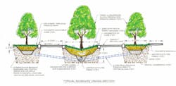
Infiltration trenches would be constructed along the roadway median and under the parking areas on either side of the roadway. A 5-foot trench would be excavated in these areas at the onset of the development. The roadway would be constructed and development of the property would ensue. While 25% of the excavated material would be stockpiled, the remaining 75% would be used as fill material for lot grading. For subdivisions, a site is usually uniformly graded and compacted to optimum moisture content (approximately 95% of maximum density or higher).
For the hypothetical redevelopment, the soils underneath the roadway lanes, driveways, and the residential pad sites would be compacted according to the same standard. However, the yards, infiltration areas, roadway median areas, and all other open areas would be minimally compacted (approximately 85% to 90% of maximum density), maximizing the permeability of the open areas on the site.
After development of the site is complete and the remainder of the site is stabilized, the stockpiled materials would be mixed with sand and then used to refill the trench, excluding the top two feet. This portion of the trench would be filled with unmixed sand. The trench along the roadway medians would be topped with topsoil and then seeded and mulched. In the proposed parking areas on either side of the divided roadway, the trenches would be topped off with geogrid filled with gravel or topsoil. If topsoil were used, the parking areas would be seeded and mulched.
Conclusions
The proposed LID design for the site provides a favorable infiltration-area-to-impervious-area ratio of 21%. The median of the divided roadway provides infiltration and surface water conveyance that can meet local design standards.
Economically, the reduced material costs for the proposed divided roadway (less paved width and no concrete storm sewer system) and reduced mass grading costs for the site more than offset a small reduction in the number of lots for the LID layout (180 lots versus 184 for the conventional development), the additional cost of a force main for the LID development, and construction costs for the infiltration features of the LID layout.
The LID layout also includes three amenity ponds and a green roadway corridor that provide an aesthetically pleasing neighborhood environment. In addition to the water quality storm that LID features are typically designed for, the infiltration features, with reconditioned soils, would be functional for larger storms, such as the storms used for design of conventional storm sewer systems.
The excess soils excavated from the infiltration trenches can be used to fill the pad sites for the residential structures on the site. In evaluating all of the above factors, it appears reconditioned soils can be successfully incorporated into a LID design in a cost-effective manner, despite the challenges posed by the high clay content of southeastern Nebraska soils.
About the Authors:
Carter Hubbard is a Water Resources Engineer with Olsson Associates. He has nine years of experience in hydraulics, hydrology, flood control, floodplain mapping, watershed master planning, erosion and sediment control, GIS development, permitting, and engineering design projects. He lives in Nebraska and has worked on water resources projects in approximately 20 states throughout the U.S. Ashley Buckwalter, CFM, is an engineering intern with Olsson Associates. Buckwalter joined Olsson Associates over three years ago while attending the University of Nebraska-Lincoln. Following her graduation in 2006, she accepted a full-time position with the water resources practice. She has been involved with stormwater detention, dam design, and stream and pond rehabilitation projects. Ben Higgins, PE, CFM, is a Program Manager with the City of Lincoln’s Watershed Management Division. He is involved with floodplain and stormwater management issues for the city. Prior to joining the City of Lincoln in 2001, he worked in both the private and public engineering sectors.


