Dongtaizi Reservoir to mitigate flood risks, capture water
China’s planned Dongtaizi Reservoir, in Inner Mongolia, will improve flood control while also supplying water for irrigation and for a nearby industrial park.
Water scarcity and severe flood risks in China have intensified over time, prompting the government to fund water conservation projects, such as reservoirs and dams. Located in Linxi County within Chifeng, Inner Mongolia, the Dongtaizi Reservoir is one of 172 major water conservancy developments outlined in China’s “National 13th Five-Year Plan” and one of 12 key livelihood projects in Inner Mongolia. This large-scale infrastructure is a vital water conservancy undertaking for the prefecture-level city of Chifeng due to the area’s immediate need for severe flood risk mitigation.
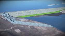
Placed in the middle and upper reaches of the Xar Moron River, a part of the Xialamulun River Basin, the Dongtaizi Reservoir will improve flood control standards in the river’s lower reaches. The reservoir will also supply water for the construction and operation of Linxi Industrial Park, a gas refinery. Lastly, the reservoir will sustainably advance the local economy by providing critical agricultural irrigation and water supply to the areas adjacent to the lower reaches of the river.
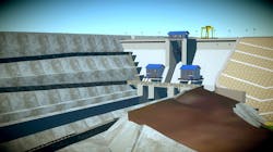
Liaoning Water Conservancy and Hydropower Survey and Design Research Institute was responsible for delivering the reservoir design. Based on the potential of a 100-year flood recurrence, the proposed infrastructure is a rockfill dam with an asphalt core wall and a concrete gravity dam. Reaching up to 43.5 meters at its highest point, the dam will have a total storage capacity of 321 million cubic meters.
Challenging Landscape and Infrastructure
The expansive location of the Dongtaizi Reservoir necessitated a precise geological survey, as the site’s terrain was complex. Therefore, the design team required a comprehensive understanding of both the rock mass that would support the prospective dam and the ground’s structural plane.
In addition to the project’s surveying demands, the infrastructure design was also multifaceted.
Engineering the rockfill dam within the difficult topography called for more than traditional methods, and the intricate structural design of the concrete dam included hydraulic and electrical engineering and a metal construction.
Furthermore, the design required an ecological fishway so that migrating fish could pass through the dam. The fishway’s multidimensional torsion entailed significant excavation processes that could not be accurately conveyed with traditional 2D design. Liaoning Water needed the visualization capabilities of modeling software to remove human errors based on spatial imagination.
Embracing Digital Design Software
The reservoir design required collaboration among multiple engineering disciplines, precise excavation drawings, an intuitive geological design, and a detailed dam design. Traditional design methodology would not achieve these results, so Liaoning Water employed Bentley’s building information modeling (BIM) software because of its cooperative design management platform.
“From the feasibility study stage of the project, the company implemented the BIM technology forward design, and removed a large number of difficulties in 3D geology, 3D excavation, and dam design,” said Wang Yixin, director of the digital and smart engineering R&D center of Liaoning Water.
Bentley Applications Overcome Obstacles
The team began by using OpenRoads to execute an accurate 3D geological survey of the dam location based on massive drilling and exploration line data. The application’s spatial analysis feature provided an audit of the dam foundation rock mass types, the structural plane, and the area’s block boundaries.
To design the complicated ecological fishway and overcome the excavation challenges, they used OpenRoads Designer to create a detailed 3D geological model, which became the foundation for the dam design. They used the model to generate a geological section expansion map, with any cutting position or direction, to formulate the excavation plan. Visualization with the 3D model eliminated design conflicts, accurately calculated excavation volumes, and connected the mined landscape to the design model of the reservoir. The BIM software also allowed the team to position the junction of the fishway’s complicated spatial curve with the terrain.
Liaoning Water also used OpenRoads’ linear engineering capabilities to design the rockfill dam section. They produced parameterized templates, assigned the cross-sections with the correct control conditions, applied the terrain boundary conditions, and generated a 3D model. This functionality enabled the project team to view any cross-section of the dam and to automatically deliver accurate quantities to create a higher-quality design.
To design the extremely complicated concrete dam and its electromechanical system, they combined multiple engineering disciplines with 3D modeling. Because this portion of the dam required hydraulic machinery and engineering as well as electricity and a metal structure, multiple engineering disciplines were implemented. Integrating Bentley software using a connected data environment enabled clash detection in OpenBuildings to pinpoint miscalculations and oversights.
“Through 3D digital modeling, the complex electromechanical system is more intuitive and dynamic,” Yixin said. “The automatic collision detection system lists the collision positions of electromechanical equipment in the form, which effectively eliminates the occurrence of errors, omissions, collisions, and defects and improves the quality of the design.”
OpenBuildings facilitated module-by-module design of the concrete dam’s many odd-shaped structures with prefabricated beams, slabs, columns, doors, and windows. This capability saved time by allowing the design team to compare various options. Additionally, OpenBuildings’ generation of quantity statistics for building elements and hydraulic components removed human-error involved in traditional engineering calculations.
Setting A New Digital Twin Standard
Liaoning Water achieved technological innovation using BIM software by combining the axial and side views of the 3D model with 2D drawings for a more comprehensive and straightforward design for the construction team.
By using the applications, the team improved design efficiency by 40 percent to deliver the engineering design two weeks earlier than anticipated. The BIM applications reduced design error by 90 percent, minimizing design changes during construction and accelerating the digital handover of construction progress to the client.
By accurately calculating the project’s cost in the design stage, Liaoning Water lowered the overall project investment. They leveraged BIM technology to deliver a digital twin that provides support on the full lifecycle of the dam, including management during construction, operations, and maintenance.
Upon completion, the Dongtaizi Reservoir will mitigate flood risk and supply water to much needed areas within the river basin. Additionally, the precise design of the ecological fishway will restore fish migration and reduce the reservoir’s overall environmental impact.
With this innovative design, Liaoning Water is the provincial leader in using BIM software for water conservancy projects. They are using this project as the foundation for the application of BIM software on other infrastructure endeavors and have already implemented corporate 3D collaborative design standards for the company and trained personnel.
About the Author: Amy Heffner is a manager of civil product marketing at Bentley Systems, focused on the promotion of Bentley’s civil design applications. She has over 15 years of experience in marketing, event planning, communications, and project management.
About the Author
Amy Heffner
Amy Heffner is a manager of civil product marketing at Bentley Systems, focused on the promotion of Bentley’s civil design applications. Joining Bentley in 2007, Heffner has held various roles in product marketing, corporate marketing, and user-focused events and trainings. She has over 15 years of experience in marketing, event planning, communications, and project management. Prior to her time at Bentley, Heffner worked as an associate producer at WPVI Philadelphia and as a marketing manager for DesignDesign, Inc., a Philadelphia area industrial and creative design firm.

