Lehigh County Authority (LCA), a public water and wastewater utility in Pennsylvania, needed a new solution to keep its more than 55,000 customers informed and safe.
LCA is responsible for 660 miles of water main and 405 miles of sewer main. The utility was using a system called Rapid Response that had no geospatial component, which resulted in employees spending too much time trying to extract information from the billing system to complete communication campaigns. If there was an emergency in the northernmost end of the city, staff would have to drive back to the office, define the area, manually extract phone numbers, and then launch the campaign to communicate with the affected customers.
Headquartered in Harrisburg, Pa., GeoDecisions is an Esri® platinum partner that builds location-based enterprise technology solutions that push GIS boundaries and help organizations make better business decisions. LCA was already using Esri’s Portal for ArcGIS, so the GeoDecisions Notify program integrated easily with its existing system.
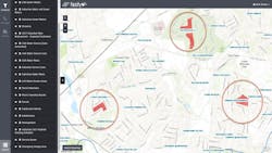
Based on LCA’s needs and GeoDecisions’ Notify capabilities, the team chose to implement Notify, an advanced, high-speed alert notification system to replace Rapid Response. Notify is designed to deliver location-based voice, text, and email messages within minutes to public and private entities.
One of the major selling points for LCA was that Notify utilizes Esri’s ArcGIS Online and Portal for ArcGIS platforms, providing intuitive, comprehensive mapping and analytics capabilities. Integration with Esri’s system architecture gives LCA the ability to seamlessly integrate countless Esri maps and applications with Notify, providing them with a solution that can grow with the organization.
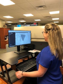
Today, LCA uses Notify as its primary customer and employee communications platform for the entire organization. This web-based solution leverages existing customer, employee, and GIS mapping information to distribute critical information quickly and securely during an emergency.
The utility has also been able to integrate other systems easily into Notify, such as Cityworks. Feature services are extracted from Cityworks and added into Notify maps to keep the customer care team up to date on scheduled preventive maintenance, such as flushing, which can generate a lot of calls.
“Notify is a real game changer for the Lehigh County Authority,” Mark Bowen, GIS and Cityworks manager at LCA, said. “By leveraging LCA’s existing Portal for ArcGIS platform, Notify has provided LCA with a common operating platform shared by both management and field staff across multiple devices.”
Notify reduces the number of customer questions and complaints related to water service interruptions. Additionally, notification of outstanding account balances can help reduce the need to turn off customer water service due to non-payment.
Overall, communication has improved significantly with Notify as the central communication tool. In addition to the Cityworks example and field staff direct updates, LCA also includes scheduled capital projects such as main and valve replacement projects in Notify. Staff can draw project polygons and add in the date of work, when to notify customers, and other important information for the customer care team. WW
About the Author: Brian Smith is senior vice president of strategy and innovation with GeoDecisions. He is responsible for directing software development, strategic business initiatives, and geographic information system (GIS) projects. He focuses on the development of business solutions using spatial data and processing to solve complex business challenges. Additional responsibilities include AR/VR Lead and Collaborative Research and Innovation Center consultant, helping bring new ideas to market. He holds a bachelor’s degree in regional planning.
About the Author

Brian Smith
Brian Smith is senior vice president of strategy and innovation with GeoDecisions. He is responsible for directing software development, strategic business initiatives, and geographic information system (GIS) projects. He focuses on the development of business solutions using spatial data and processing to solve complex business challenges. Additional responsibilities include AR/VR Lead and Collaborative Research and Innovation Center consultant – helping bring new ideas to market. He holds a bachelor’s degree in regional planning.


