Enterprise GIS: Creating a ‘Place of Opportunity’
With Esri’s ArcGIS mapping platform, Northern Ireland Water got the functionality it needed as well as a suite of additional tools
By Sean O’Boyle
Northern Ireland Water was founded in April 2007 as a government-owned company to provide water and sewerage services for 1.8 million people in Northern Ireland. In its first decade, the company underwent a significant transformation, developing new operating models to enhance the way it delivered customer services and maintained 42,300 km of water mains and sewers. By 2017, however, the company’s aspirations for continued business improvement were being constrained by its two separate, existing geographic information system (GIS) applications.
The need for location-based services was growing throughout the organization, not only for office-based applications but also for the mobile workforce. Northern Ireland Water needed to replace its fragmented approach to GIS with a single enterprise system that would support the entire organization and fuel its drive to deliver even better customer services.
The Solution
Northern Ireland Water selected Esri’s ArcGIS because the solution’s capabilities exceeded the organization’s predicted requirements. ArcGIS provided all of the features and capabilities the utility was looking for — but also took NI Water to a place of opportunity. The utility can now rapidly deploy new web and mobile applications using standard, out-of-the-box ArcGIS tools to meet new business requirements — and it can all be done in house.
With support from Esri Ireland, Northern Ireland Water completed the initial project implementation at an impressive pace, moving from no ArcGIS capabilities at all to a full enterprise ArcGIS platform in less than a year. The consultants from Esri Ireland passed on their knowledge to employees during the project, so that by the time the systems went live, in-house teams were competent in using and managing ArcGIS. The whole project went live on budget and on time, according to the schedule that was set on day one.
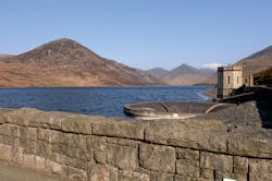
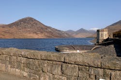
Northern Ireland Water was founded in April 2007 as a government-owned company to provide water and sewerage services for 1.8 million people in Northern Ireland.
ArcGIS is now used daily by hundreds of users and is available to 1,035 employees in total. It is integrated into key workflows right across the organization and is a core part of its Corporate Asset Register, the second most used application within the business after email.
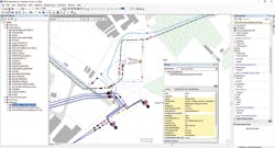
A key solution for Northern Ireland Water is Esri’s ArcGIS for Water Utilities, a set of maps, services, apps and automated processes that have been specifically developed to meet the needs of international water companies. The integrated nature of ArcGIS means that business specialists can edit asset or customer data using ArcGIS on the desktop and then make it instantly accessible to employees via web apps and mobile solutions, all at the click of a button.
ArcGIS for Water Utilities — network editing tools are fundamental to data management in the Corporate Asset Register.
The benefits realized by Northern Ireland Water include:
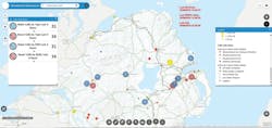
Responsive services for customers: The enterprise-wide implementation of ArcGIS gives all employees in the organization instant access to accurate location information, which they can use to help them deliver a more responsive customer service. For instance, the locations of all issues reported by customers are streamed in real time on a web map. Displayed on a four-meter screen in the customer call center, this situational awareness map allows incident managers to better monitor the situation in real-time and react quickly to resolve issues.
More efficient business processes: ArcGIS has improved business efficiency by replacing numerous manual, paper-based processes and eliminating the unnecessary duplication of data. In the Developer Services team, for example, engineers now use ArcGIS to design water main networks for planned new residential developments significantly quicker than before, enabling them to deliver a fast, professional and cost-effective service for customers.
A streamlined approach to capital delivery: Northern Ireland Water has exploited the seamless functionality of the ArcGIS platform to build a successful proof of concept, which delivers the capability to manage the complete life cycle from engineering design through approvals, construction and on to “as built” asset records, making what Paul Davison, head of water capital delivery at Northern Ireland Water, describes as “a step change in collecting accurate asset data.”
Northern Ireland Water’s situational awareness web map provides managers with a clear overview of customer issues in real time.
Enhanced safety for personnel working in the field: Using Esri’s Survey 123 for ArcGIS, Northern Ireland Water is now developing a new mobile app that will help the company to identify and respond to potential health and safety risks more quickly. Employees will use their smartphones or tablets to collect data in the field about the locations of trenches, equipment, infrastructure and other potential hazards. Whereas this information might previously have taken up to two weeks to be typed up in a report, it will be transferred to the head office in real time, saving time and allowing managers to intervene rapidly if a safety issue is identified.
Better informed decision making: In a wide variety of ways, ArcGIS gives senior managers at Northern Ireland Water faster access to better quality information. The organization’s Chief Executive Sara Venning said: “Northern Ireland Water’s new Corporate GIS, implemented using Esri technology, gives us the advantage of being able to swiftly deploy spatial solutions to aid decision making. This has been particularly evident during incident planning where logistics and location information is of critical importance to us in striving to respond rapidly to our customer needs.” WW
About the Author: Sean O’Boyle is the asset information development manager for Norther Ireland Water with responsibility for its corporate asset systems, location-based services, and GIS functionality and applications across many business areas including asset management, engineering, operations, finance, work management and customer service.
Circle No. 311 on Reader Service Card


