Flood Control Project Meets Practical, Aesthetic Goals
by Scott Buchanan
The "Sonoqui" (pronounced so-NO-kee) were a local Native American people who vanished from the Phoenix, AZ, area around a thousand years ago. The wash that now bears their name originates in neighboring Pinal County and passes through the towns of Queen Creek and Gilbert as well as unincorporated Maricopa County about 40 miles southeast of Phoenix. The wash has a contributing area of around 70 square miles comprised of farm fields, unimproved desert including the San Tan Mountains and medium density residential subdivisions. According to the HEC-1 regional watershed model, the 100-year discharge for Sonoqui Wash ranges from 1,800 cfs near the upstream project limit to 2,400 cfs at the downstream end.
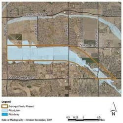
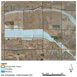
Before channelization, the 100-year floodplain of Sonoqui Wash covered an area of nearly 800 acres from the upstream to the downstream project limit (see Fig. 1). The floodplain escaped the channel banks in the upper project reaches and was up to 1/2 mile wide in the lower reach. It affected about 160 homes that were constructed over many years prior to identification of the floodplain. The wash narrowed as it traversed downstream through agricultural fields until it was no more than a shallow tail water ditch choked with native trees and brush. Unlike the upper reach, much of the farm area around the lower reach was being developed with medium density residential subdivisions (see Fig. 2).
The need to address Sonoqui Wash flood hazards became apparent when its floodplain was delineated several years ago. Because of the magnitude of flow, the extent of the floodplain and the fact it crosses multiple jurisdictions and properties, the channelization project became a regional flood control responsibility. The Flood Control District of Maricopa County served as the lead agency with the towns of Queen Creek and Gilbert participating as cost-sharing project partners through intergovernmental agreement. Much of the land needed for the project was dedicated by adjacent property owners and developers. Part of the upper reach had been set aside as a subdivision drainage tract long ago. Queen Creek and Gilbert acquired the remaining land needed for the project and now own and maintain the constructed channel.
The Sonoqui project's main objective was to capture the 100-year flow and convey it through the developing rural area to Queen Creek Wash and the East Maricopa Floodway, which are the regional flood control outfall channels for southeast Maricopa County. But there was also significant opportunity to provide an aesthetic amenity and a linear open space to serve future multi-use trail and park objectives for both equestrian and pedestrian activity.
The engineering firm of Stanley Consultants was engaged to develop plans, specifications and an estimate of probable cost for an earth flood control channel just over 4 miles long, based on a concept level regional master plan concluded a few years earlier. The improved channel generally follows the existing Sonoqui Wash alignment but 3,500 feet was constructed with a new southerly route to distance the channel from a major arterial road intersection. The old channel in this reach was filled in during construction.
The project began with an extensive pre-design effort involving Stanley Consultants' landscape architect and environmental sub-consultant Logan Simpson Design. The pre-design effort included assessments of existing landscape character, scenic views and recreational opportunities along with the development of aesthetic treatment concepts and a landscape master plan in accordance with the Flood Control District's aesthetic and multi-use design guidelines. Sonoqui Wash will serve as a major trail corridor with capabilities for equestrian use that link regional and local parks and recreation facilities. One of the larger design challenges was to maintain proper balance between the hydraulic flood control function and the aesthetic, multi-use and non-engineering aspects. To help shape the aesthetic and multi-use approach, the project incorporated public involvement meetings and a project aesthetics advisory committee (PAAC) consisting of local appointed citizens.
A Section 404 Waters of the U.S. jurisdictional delineation, pre-construction notification and mitigation plan was prepared by the Flood Control District of Maricopa County and approved by the U.S. Army Corps of Engineers prior to construction. There was one historic site near the project but no archaeological conflicts were found. Protected native burrowing owls inhabiting a portion of the channel were relocated by a wildlife specialist.
Refinements to the regional hydrology model yielded final design discharges and an iterative design process for the channel was conducted starting with a preliminary base profile and typical hydraulic sections. The base design was then contoured by the project team's landscape architects using side slopes varying from 4:1 to 8:1 and meandering the channel bottom laterally to resemble a more natural desert wash. Earth mounding was also created outside the channel proper. Where possible, this grading was expanded and shared with streetscape grading in adjacent road right-of-ways creating a larger, more open effect than would have been accomplished using the channel corridor alone. Hydraulic backwater analysis was then conducted incorporating the aesthetic channel contours, and further adjustments were iterated until the channel had the desired look, contained the design flow and met velocity, freeboard and superelevation criteria.
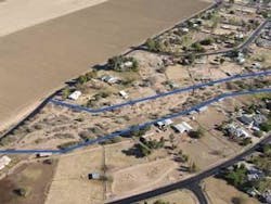
From the beginning, the Sonoqui project was designed to accommodate equestrian use, primarily associated with the older subdivisions in the upper reaches. New bridge structures for arterial roads at both ends of the project were designed with a minimum vertical clearance of 12 feet. A hydraulic design and structure selection report was conducted for future all-weather bridge or culvert crossings at three other arterial roads that also incorporated minimum vertical clearance for equestrian use. There was no designated equestrian path to be constructed within the channel corridor so it was desirable for all slopes and surfaces to be as traversable as possible by horse and rider (see Fig. 3).
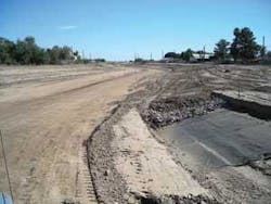
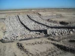
Incorporated in the design were six drop structures ranging from 1.5 to 5 feet in height. The drop structures flatten the longitudinal channel slope, slow the flow and also provide grade control to combat scour. Although flow velocities in the channel were relatively moderate, around 4 to 7 feet per second for a 100-year event, native soils were light and susceptible to erosion. Therefore, the channel also needed continuous bank protection. Many design alternatives were considered, particularly from an equestrian use standpoint. Loose riprap was chosen for the bank protection and recessed below the finished channel surface so it could be covered by a 12-inch thick layer of native soil (see Fig. 4).
Drop structures consisted of an upper and lower reinforced concrete cutoff wall with a 10:1 slope between them. That space was filled with a layer of grouted riprap. Plain riprap aprons were placed above and below the cutoff walls and, like the bank lining, recessed and covered with a 1-foot-thick layer of native soil. The native soil cover is considered "sacrificial" during large flow events but should withstand the more common low flows, especially after hydro-seeding and landscaping are established. The additional maintenance anticipated for this design was a tradeoff in favor of the equestrian function and acceptable to project partners Gilbert and Queen Creek, who will be responsible for maintaining their respective reaches. An in-line sediment basin consisting of a wider, flatter and deeper reach of channel was designed at the downstream project limit. Its sediment trapping function was modeled with HEC-6T.
An off-line detention basin with a 160-foot-long reinforced concrete lateral inlet weir was incorporated near the upstream end of the project. This basin was roughly 15 acres and at its peak stage would store 40 acre feet of Sonoqui Wash flow. The design allows for low flows in the channel to bypass the basin until the peak arrives, thus maximizing attenuation while minimizing storage. The bypass function was analyzed hydraulically using the HEC RAS unsteady flow module to optimize design of the weir height and length and the basin configuration. The volume stored in the basin bleeds off into the channel downstream via 24-inch diameter ungated outlet pipe within the 36 hours required by design guidelines. The discharge attenuation downstream provided by the basin helped contain the flow within the narrowest part of the corridor, which is only 135 feet wide.
The project included reconstruction of six roadway crossings and numerous private driveways; relocation of many water and sewer utilities and private irrigation facilities, including standpipes and inverted siphons, along with electric power, natural gas and communication utility relocation, and removal and disposal of buried material from an old wildcat landfill. There was extensive coordination, both before and during construction with two concurrent bridge projects, adjacent roadway, sewer, water transmission and water treatment plant projects, a water recharge project, a 69kv overhead electric power line and on-going residential subdivision improvement projects. A Conditional Letter of Map Revision (CLOMR) was submitted to FEMA and approved near the end of the design phase. As-built drawings and application for final revision of flood insurance maps to reflect the project are being reviewed by FEMA.
Construction of the project was completed in March 2008 by contractor Rummel Construction. Maricopa County uses a partnering process, which was considered tremendously successful for this project. Although the wash is typically dry and has not flowed for years, during construction flows occurred from three separate heavy rainfalls. Despite delays caused by rain and mud, construction was completed in nine months, which was well ahead of schedule. The successful project bid was well under the engineer's estimate because of the competitive economic climate and because of the contractor's proactive approach in pre-arranging spoil sites on adjacent and nearby properties. Future improvements under separate projects will include all weather road crossings, landscaping, multi-use paths and the Stage Stop Equestrian Park mentioned earlier.
About the Author:
Scott Buchanan, P.E., CFM, has been a project manager in Stanley Consultants' Phoenix office for 18 years and is the company's chief water resources engineer.
