
Data management, GIS mapping improve operations at Washington’s Clark Regional Wastewater District
Clark Regional Wastewater District is one of the largest sewer service providers in the state of Washington, supplying environmentally responsible wastewater services to a rapidly growing population covering an area of more than 47 square miles.
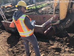
The District’s Engineering Department maintains a full Geographic Information System (GIS) service for sanitary sewer services across the region. One of the primary services they provide is performing on-site inspections for the construction of new system connections and sewer infrastructure.
The District currently adds 1,800 Equivalent Residential Units (ERUs) to its infrastructure every year and has over 200 ongoing development and capital projects in various stages of completion.
The Challenge
Previously, when a construction project required a new or altered sewer connection, contractors would contact the District to request a site inspection by telephone or email on an ad hoc basis. Once these requests were received, administrators would generate paper forms that would sit until they were picked up by an available inspector.
“A good 20 percent of the time some information was wrong, so the inspector would have to call the contractor, find out what the real information was, and then go from there,” Tom Sedlacek, senior engineering technician (GIS) for the District, and a major champion for developing digital solutions, said.
Inspections involved recording test results and creating field sketches with pen and paper. After each inspection, the sketches were brought back to the office and copied by hand onto forms that were returned to admin for processing. Wet conditions caused further data accuracy challenges when transcribing data from documents and correctly associating sketches with inspections filled out in the rain.
With paper forms, there was no centralized database and information was stored in multiple systems. Time-consuming email chains and meetings were required to track the status of a given inspection or project, which also led to accidental data duplication.
The solution
Realizing that it was not taking full advantage of advances in data management technologies, the District began working with GIS and data analytics consulting firm FLO Analytics to analyze its requirements. Together, they realized they had an opportunity to digitize the District’s inspection process to achieve significant efficiency gains.
The ability to tie mobile data collection apps directly to GIS software emerged as a core functionality requirement. This would ensure field data remained tied to assets geographically throughout the inspection and review life cycle. The District could also benefit from better access to records via a centralized SQL database and improved reporting through data visualizations. After FLO Analytics conducted a thorough evaluation of the options, Flowfinity was selected as the platform that would take the District to the next step.
“One of our first tasks was to find a good field form app. We wanted to keep our systems as GIS-centric as possible,” Sedlacek said. “Other Esri-compatible solutions that were Excel-based didn’t really lend themselves to the dynamic data that we needed. Flowfinity is SQL based and provides a much more dynamic central database.”
Dispatch and Data Collection
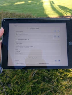
Data collection apps built and hosted on the Flowfinity platform have significantly streamlined site inspections at the District. Paper forms have been replaced with digital records created using mobile apps that guide inspectors through all required steps, greatly reducing the time required per inspection and data entry errors. Permit inspection requests are now primarily placed online through a website integrated with a Flowfinity database and Esri mapping software. Permit requests are accessed on a map in real time to launch or update inspection records. Automatic email notifications are sent to contractors, saving time and improving communication.
“When we get a new permit in, it goes directly into Flowfinity. It is matched to a GIS polygon and placed on our map, and once it’s completed the polygon will be automatically removed from the map,” Sedlacek said.
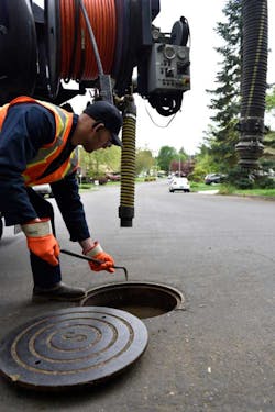
On-site photos are taken using mobile devices and immediately stored in Flowfinity. Annotations can be added to highlight special instructions or concerns, while high-precision GPS locations are recorded with a commercial antenna. Scanning and deciphering hand-drawn diagrams are a thing of the past.
GIS Mapping
FLO Analytics helped the District with coding integrations that share permit data stored in Flowfinity with Esri ArcGIS mapping software. This means that data collected in the field is tied to GIS maps and vice versa. A field inspector can identify the location of an asset on a map, then launch an inspection in Flowfinity with a tap of their finger.
“Flowfinity’s SQL back end allowed us to develop innovative data integrations directly with the Enterprise GIS system, allowing for easy map display and interactions.” Grant Herbert, director of technology at FLO Analytics, said.
This integration ties two vital systems together in a way that improves user experience while ensuring data integrity is maintained. There is no risk of duplicate inspections or erroneous location data to slow reporting and analysis. Inspection details are viewed in Flowfinity records launched from markers on an area map in ArcGIS.
“I click the job icon on the map, and here’s all the information that comes out of our finance software. From the map, I click on ‘Start Inspection’ and it launches Flowfinity. It’s just like magic every time I do this,” Sedlacek said.
Tracking and Reporting
All field data collected is stored instantly in a centralized, dynamic database. If there is no internet connectivity on-site the data will be stored on the device and uploaded when a connection is available, providing reliable offline functionality. When an inspection is submitted from the field, it is instantly accessible for review by office-based admin staff. Gone are the days of waiting for paper forms to return. Daily reports are automatically generated and distributed summarizing the previous days’ inspections, which can also be easily visualized in real time on a digital map, replacing meetings and emails.
The Results
In the first year, 373 hours of labor were saved, primarily in data entry and recordkeeping, leading to a 60 percent project cost recovery. Having the ability to immediately access data and track permits has also dramatically decreased response times and resulted in improved customer service.
The department projects a 160 percent ROI within five years, while Sedlacek and his colleagues continue to innovate new ways to streamline operational processes that are not included in that calculation.
The department is receiving positive input from engaged staff, leading to more apps being built to satisfy other process gaps as employees continue to analyze their workflows and ask, “Can you build an app for that too?”
The accessibility of no-code app configuration lends itself well to an iterative approach to continual improvement of field data collection workflows and is allowing Sedlacek, GIS analyst and Flowfinity app builder, to tell end users to “dream as big as you can.”
Next Steps
The District hopes to leverage dashboard reporting, integrated with GIS, to drive field operations and business performance as the next phase of its Flowfinity journey. Future iterations may also incorporate more process automations to achieve even greater efficiencies. Sedlacek and his department will continue to take a modular approach to their systems and update apps as new functionality is released.
FLO Analytics continues to work with the District and other clients in both the public and private sectors to leverage GIS and data analytics to create bold and innovative solutions. WW
About the Author
Alex Puttonen
Alex Puttonen has nearly 20 years of experience providing technology consulting to public sector departments throughout North America, with a current focus on digital field data collection and mapping solutions for utilities. Learn more at www.flowfinity.com.