Advances in data collection, artificial intelligence, and geographic information system (GIS) technology provide numerous benefits to municipalities. Workers in all departments can more effectively track maintenance needs, identify options for delivering the highest level of service, and utilize resources at the optimal level.
In addition, the ability to visualize existing infrastructure and assess how changes will impact the community facilitate good planning and future development. With the right tools, asset management is conducted efficiently and decisions are based on up-to-date information.
Lowering Maintenance
Like many small towns, the City of Hernando, located in northwest Mississippi, lacked an accurate record of its infrastructure, both above and below ground. Outdated information on paper maps led to contractors damaging pipes, and emergency response was hindered by a lack of accurate information about the city’s assets. When evaluating resource availability for new developments or repairing damage, the Public Works Department had to use outside contract for new surveys, which incurred added expenses and delays.
“Our service area is about 40 square miles and we’re responsible for ditch banks, sewer lagoons, 30 sewer lift stations, five water towers, and everything related to the water system — valves, mains, storm drains,” says Lee Germany, the public works director for the City of Hernando. “It could take hours for us to locate breaks and determine where to turn off valves. We really needed a better method to know where our assets are located.”
With inaccurate as-built information contributing to damaged pipes and interrupted service, the city committed to developing a GIS in 2020. By combining base map information with newly collected GPS coordinates and detailed descriptions of assets in an online GIS, a wealth of information became easily accessible.
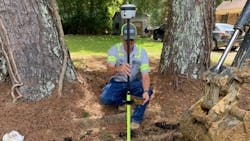
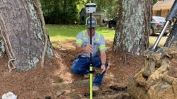
To start, existing data was compiled into a central database, enabling users to continuously upload new information and make corrections. TerraFlex, a cloud-based solution that runs on smartphones and tablets was used to collect the GPS coordinates of assets in Hernando. Field crews also used a R2 GNSS receiver that provides 1- to 3-centimeter positioning accuracy. The workflow pushes new data from the field to the office when online, or stores data on the device if offline.

Field crews are now able to collect GPS coordinates and descriptions for important assets, such as water valves, water mains, and storm drains — and they can remotely access the exact location of their infrastructure, expediting repairs and maintenance. In addition to dedicated data collection efforts, GPS data is captured when old pipes are being repaired, and new subdivisions are required to provide accurate as-builts for infrastructure assets that are relevant to the public works department.
“Our customer service has improved because the GIS allows the crew to see how our assets are connected,” says Germany. “They can quickly locate shut-off valves and calculate how many customers will be impacted by breaks. When called out to a site, they bring the right equipment to make the repairs instead of making multiple trips.”
Artificial Intelligence to the Rescue
The City of Charlotte, N.C., faced a different problem — locating water meters throughout Charlotte Water’s extensive service area to expedite service calls.
Several sources of information had been used in the past to establish meter sites — including as-builts, Google Street View, aerial imagery, and surveys — but still only 30 percent of the city’s 300,000 meters were verified. These approaches were primarily manual and costly: the city spent around $400,000 to locate meters in 2019.
Charlotte Water turned to consultants for help creating an innovative mapping solution to speed up verifying the locations with mobile mapping imagery. After completing a test project using GoPro imagery and evaluating the pros and cons, Charlotte Water decided to move forward on a large-scale effort using a MX7 mobile mapping system.
By integrating the precision detail of the mobile mapping with Esri’s artificial intelligence (AI) algorithms, the agency developed a system that automatically detects each meter and maps its exact location. The new approach provided a cost-effective, repeatable alternative to manual verification.
The mobile mapping system is mounted on a city vehicle, which offers several advantages for Charlotte Water’s high-volume data capture needs. The MX7, for instance, has six cameras for 360-degree collection, which is helpful for seeing around obstacles, and 30-megapixel resolution which shows up-close details. The navigation sensors and imaging sensors are designed to collect georeferenced images at highway driving speeds for maximum productivity.
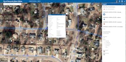
Charlotte Water uses Esri ArcGIS Pro to map and display multiple GIS layers, such as parcel boundaries and streets, along with the latitude/longitude coordinates of the water meters generated by the model. With the object identification handled automatically, human workers can focus on maintaining the City’s assets and maximizing its resources.
“The mobile mapping system will allow us to accurately map all 300,000 water meters in two to three years, compared to eight to 10 years using manual methods,” says Shannon Martel, GIS Manager, Charlotte Water. “Up-to-date location information is vital for reducing our maintenance costs and enhancing our customer service.”
With access to a current database of asset locations and descriptions, collected with the latest hardware and software, municipalities are better equipped to utilize available resources wisely. An in-house GIS puts information at the fingertips of the people who need it most, to help them respond quickly and efficiently to service outages or routine repairs and help them make decisions about growth and sustainable development. WW
About the Author: Linda Duffy has worked as a freelance writer and market researcher since 2003. She specializes in geospatial technology.
Published in WaterWorld Magazine, April 2022.
About the Author

Linda Duffy
Linda Duffy has worked as a freelance writer and market researcher since 2003. She specializes in geospatial technology.