Savannah Riverkeepers Manage and Share Data for Improved Decision-Making
By Tonya Bonitatibus, Damon Mullis, Rosco Peters, Lindsay Wallace
The Savannah Riverkeeper and Ogeechee Riverkeeper have used Esri products to facilitate the public’s access to their river basin data and subsequently created a powerful public resource.
An Abundance of Data
Hundreds of thousands of water samples are collected on waterways throughout the United States every year by multiple agencies, organizations, and individuals. Each sample helps tell a story about the health of a waterway and its ability to handle stress from a variety of sources. Those datasets are housed in various physical or digital locations and in different formats, making it difficult to make holistic, better-informed decisions.
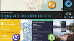
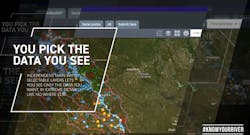
Know Your River is a powerful tool, built using Esri technology, that collates data from over 40 sources into one interactive mapping and dashboard interface. Data is organized with an emphasis on ease-of-use and features four maps: Recreation, Surface Water, Groundwater, and Environmental Justice.
The Know Your River tool was built for two river basins as a pilot and has greatly benefitted home buyers, re-creators, scientists, activists, and agencies alike. It features a growing list of scientific studies on the Savannah and Ogeechee Rivers. It was built with a focus on data democratization using ArcGIS Hub, heavily relying on Esri tools such as ArcGIS Online, ArcGIS AppStudio, and ArcGIS Survey123.
The solution began with a giant spreadsheet listing as many water quality data sources for the Savannah and Ogeechee River basins as possible. Priority was placed on finding real-time data from data loggers or web services.
The Savannah Riverkeeper and Upper Ogeechee Riverkeeper are launching water data loggers to collect real-time data on temperature, dissolved oxygen, water level, pH level, and other important parameters. This data will be displayed in online maps using the manufacturers’ APIs.
The Savannah Riverkeeper and Ogeechee Riverkeeper trained citizen scientists who regularly collect water quality and visual inspection data from dozens of sample locations. These citizen scientists utilize Esri’s Survey123 application to upload data to the Know Your River dataset. Water quality parameters from samples tested in the lab are uploaded as soon as test results are available.
Other real-time web services data include the USGS REST web services and the Water Quality Portal. Data available online (but not as a web service) was also downloaded from various sources and uploaded for display on the Know Your River hub. Other data, not available online, was requested from cities and nongovernmental organizations. These datasets were gathered and are now available as a web service from the Know Your River tool.
Future Plans
The plans for Know Your River are to expand services and overcome barriers to data analysis. The solution will use a dedicated backend database to aggregate similar data, complete a dashboard of tools to analyze the aggregated data, offer users the ability to receive real-time data alerts, and expand the project to other river basins. WW
Esri is exhibiting at WEFTEC22, booth 6539. To learn more, visit www.esri.com.
Published in WaterWorld magazine, September 2022.

