A Century of Colorado River Rules Meets a Drier Reality
If you've been following the Colorado River lately, you know the story keeps getting bigger. On October 16, Arizona announced it was joining Nevada's lawsuit against the federal government over how the river will be managed. Nevada filed its suit in August, challenging the Department of the Interior's plan for the river.
This week on Talking Under Water (Episode 170), we covered the news and then took a longer walk through the history behind it. Here's the full version for those who prefer to read.
The dispute in a nutshell
The lawsuit centers on a fundamental question: should the Lower Basin states be required to absorb major water cuts while the Upper Basin states aren't required to make comparable reductions?
Under the federal framework, Arizona, California and Nevada face potentially significant reductions to the Colorado River supplies they are owed under the original pact. The Upper Basin states of Colorado, New Mexico, Utah and Wyoming aren't required to make equivalent cuts under the new plan.
Arizona argues that the federal government hasn't adequately considered alternatives that would ask more of the Upper Basin. Those include requiring or encouraging more conservation there, changing how water is released from federal reservoirs, coordinating reservoir operations differently, and finding ways to store conserved water so it's available when the system needs it most. Arizona is also challenging the federal environmental review behind the decision.
The federal government sees it differently. It says its framework provides the flexibility to manage critically low reservoirs, protect infrastructure and continue negotiations. The legal question is whether the government has struck the right balance while complying with the Law of the River.
The stakes, in acre-feet and gallons
Arizona's state officials say the proposed reductions would threaten communities, agriculture, businesses and the state's economy. In the scenario being challenged, Arizona could face a reduction of up to 760,000 acre-feet annually. California's reduction could reach 440,000 acre-feet, and Nevada's 50,000.
An acre-foot is about 326,000 gallons, so those three reductions together come to roughly 407.5 billion gallons of water a year. That's 407,500,000,000, or 407.5 followed by eight zeros.
There's an important distinction in Arizona's move, too. The state wants to preserve a separate, near-term agreement being negotiated among Arizona, California and Nevada to conserve water in 2027 and 2028. So Arizona is challenging the longer-term federal framework while trying to keep a short-term path to cooperation alive.
Listen to the article on Talking Under Water
The real challenge: planning under uncertainty
This brings up another problem facing the basin, and it's one that water professionals feel more than most. Utilities, farmers, cities and industries make decisions years, sometimes decades, in advance. They need to know how much water they can reasonably expect, what conservation measures to plan for, and whether expensive infrastructure investments will still make sense under future operating rules.
The federal government has established a framework through 2036, but the operating guidelines are generally expected to be revisited every two years unless the states reach longer-term agreements.
The government's argument is that flexibility is necessary. River flows change, reservoir levels rise and fall, and a rigid plan could be difficult to operate during an extended drought. That's a reasonable point.
The other side of the argument is that flexibility can become uncertainty when the states still don't agree on who should bear the shortage. A water provider planning a new supply project or a farmer deciding what to plant can't necessarily wait for the next round of negotiations to find out what the rules will be. That's one reason the states have been pushing for a durable agreement. They need more than a way to get through the next two years. They need a reasonable basis for planning the next 10, 20 or 30 years.
The challenge is finding rules that are predictable enough to plan around, but flexible enough to manage a river whose flows are increasingly unreliable.
How did we get here?
To understand the current fight, we have to go back to 1922. But first, the geography, because the names can be confusing.
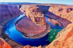
The Colorado River begins high in the Rocky Mountains of Colorado, flows southwest through the Grand Canyon, forms part of the Arizona-Nevada border, and continues toward Mexico. The river basin covers parts of seven states: Arizona, California, Colorado, Nevada, New Mexico, Utah and Wyoming.
The Upper and Lower Basins aren't simply the northern and southern halves of the map. They're defined by a specific point on the river called Lee Ferry, near the Utah-Arizona border, just downstream from the confluence of the Colorado and Paria rivers. Under the 1922 Colorado River Compact, the Upper Division states are Colorado, New Mexico, Utah and Wyoming, and the Lower Division states are Arizona, California and Nevada.
Here's the weird part: the legal definitions include portions of Arizona, New Mexico and Utah in both basins, depending on which part of the river system supplies the water. So this isn't a neat line of latitude. Think of it less as a geographic border and more as a legal and hydrological dividing line.
A quick aside on drawing borders
Indulge me for a minute, because this is a fun case study. In the 19th and early 20th centuries, people had a hard time even pinning down latitude and longitude. The borders separating California, Nevada and Arizona were never a single line drawn at one time. They evolved over a century of territorial expansion, political maneuvering, grueling wilderness surveys and a shifting waterway: the Colorado River.
Because longitude calculations in the 19th century were tied to precise timekeeping, a discrepancy of just one second on a surveyor's clock could shift a border by over a thousand feet on the ground. That math problem, combined with the fact that rivers naturally change course, led to armed local standoffs, major map errors and eventual U.S. Supreme Court intervention.
Take the Sagebrush War of 1863. Early California and Nevada authorities didn't know exactly where the 120th meridian was, so both states claimed a settlement called Honey Lake Valley. Plumas County (California) and Roop County (Nevada) both sent tax assessors to the same residents. It escalated into an armed standoff, with local militias blockaded inside a log cabin exchanging gunfire. A temporary border survey later showed the town belonged to California.
What the 1922 compact actually did
Back to the river. The compact divided its water between the two basins, not necessarily along the lines of the politically defined states. At the time, the seven basin states were trying to settle competing claims and set up a framework for developing the river: building dams, delivering water to farms and growing cities, and supporting economic development across the Southwest.
Each basin was allocated 7.5 million acre-feet per year for beneficial consumptive use, and the Lower Basin was also given the right to increase its use by another million acre-feet annually. The compact required the Upper Basin states not to deplete the river's flow at Lee Ferry below a total of 75 million acre-feet over any ten consecutive years. In simple terms, that created a delivery obligation measured over a decade, rather than the same amount of water every single year.
The compact itself did not assign each state its final share. Later agreements and court decisions did that. In the Lower Basin, the allocation ultimately became 4.4 million acre-feet annually for California, 2.8 million for Arizona and 300,000 for Nevada. In 1948, the Upper Colorado River Basin Compact divided the Upper Basin's allocation among Colorado, New Mexico, Utah and Wyoming, primarily by percentages. Arizona also has a small Upper Basin entitlement of 50,000 acre-feet annually.
Those figures help explain why Nevada's position is so different from Arizona's or California's. Nevada's nominal allocation is small, but Southern Nevada has become heavily dependent on the river. Las Vegas wasn't even officially founded until May of 1905, only 17 years before the compact, and the Las Vegas Strip didn't begin until 1941. Nobody in 1922 could have known a city in the desert would eventually need so much water. Today the valley has about 2.5 million residents and hosts between 38 and 43 million visitors a year.
There's one more major piece of the puzzle: Mexico. A 1944 treaty established a U.S. obligation to deliver 1.5 million acre-feet annually to Mexico under normal treaty conditions. That obligation, along with the allocations to the two U.S. basins, adds to the pressure on the system.
Water on paper versus water in the river
Here's the crucial historical context. The original compact was based on estimates of how much water the river could provide, and those estimates relied on historical records that included unusually wet years. We now know the river's long-term average flow is lower than the amount assumed in the original framework. In other words, the states divided up water on paper that the river cannot reliably provide.
What's fair?
This is where my mind always goes: what's fair?
Imagine the Colorado River actually produced enough water to satisfy the original framework, with enough supply to meet the basins' allocations and the treaty obligation to Mexico. Would the original agreement look like a fair deal?
In some respects, you could argue that it would. The compact created a relatively straightforward framework: the two basins received comparable base allocations, the Lower Basin was allowed additional use, and the states could develop infrastructure and plan for the future. It was a negotiated settlement intended to prevent conflict and make development possible.
But fairness depends on what you're measuring. Are we talking about fairness between the Upper and Lower Basins? Between individual states? Between cities and agriculture? Between today's water users and tribal communities whose water rights were not fully addressed by the compact in the first place? Those are very different questions.
The compact didn't resolve every issue. It left the states to work out many of the details, and later agreements, federal laws and court decisions built a complicated body of rules known as the Law of the River. Even if the river had enough water to meet the original allocations, that wouldn't automatically mean every part of the arrangement was fair to every user.
But scarcity changes the debate dramatically. When there's enough water to go around, an allocation can seem like a reasonable compromise. When there's not, the same allocation becomes a fight over who has to absorb the shortfall. That's essentially the problem facing the basin today.
The Lower Basin argues that the Upper Basin should share more of the burden. The Upper Basin's legal obligations, the amount of water it actually uses, and the distinction between delivery requirements and reductions in use are all part of the complicated legal dispute. And the federal government has to decide how to operate the system while the states disagree about what the rules require.
Seven states, seven different relationships with the river
These seven states don't all depend on the Colorado River in the same way, so here's a quick tour.
Arizona gets water from the Colorado River, groundwater, in-state rivers and treated wastewater. The Central Arizona Project canal carries Colorado River water hundreds of miles inland to serve communities and agriculture, including the Phoenix and Tucson areas, which makes river reductions especially consequential for parts of central and southern Arizona.
Nevada also uses groundwater and reclaimed water, but Southern Nevada relies heavily on the Colorado River, delivered from Lake Mead. The Las Vegas Valley Water District and Southern Nevada Water Authority have invested heavily in conservation, recycling and infrastructure to stretch that supply.
California has a much larger and more varied water system, drawing on the Colorado River, the State Water Project, the Central Valley Project, local rivers and reservoirs, groundwater and other supplies. Colorado River water is especially important to agricultural areas in Southern California, including the Imperial Valley, as well as parts of the state's urban water system.
Colorado draws on the Colorado River and its tributaries, along with other rivers, reservoirs and groundwater. Much of the state's population lives on the eastern side of the Rocky Mountains, and water is moved across the Continental Divide to supply some Front Range communities.
Utah relies on the Colorado River and its tributaries, along with other river systems, reservoirs and groundwater. The river is particularly important in parts of the state's rapidly growing southwestern region.
New Mexico uses water from the Rio Grande, the San Juan River, other surface waters and groundwater. Its Colorado River Basin supplies include water associated with the San Juan River system, which connects to the broader Colorado River system.
Wyoming draws on the Colorado River and its tributaries, along with other river systems and groundwater. The river's headwaters originate in the Rocky Mountains, but the Colorado is only one part of Wyoming's wider water supply.
The important point is that every state has a different mix of supplies, demands and alternatives, so a reduction in Colorado River water won't affect every community or sector in the same way. And while other supplies can help, they aren't always easy or inexpensive to replace. Groundwater can be limited, new reservoirs are difficult to build, transfers require infrastructure, and reuse has to be developed and managed carefully. There's no simple substitute for millions of acre-feet of missing river water.
So where does this leave us?
Arizona joining Nevada's lawsuit raises the pressure on the federal government to reconsider how it plans to manage the system beyond the current operating rules. But the legal challenge is only one part of the story. The states still need to negotiate how to share shortages, how much conservation each basin should undertake, and how to manage reservoirs through years of low runoff. The current framework is not a permanent solution to the imbalance between supply and demand, so the questions raised by this lawsuit aren't going away anytime soon.
How should the burden be divided between the basins? Should reductions be tied to existing legal rights, actual water use, historical development, or some combination of those factors? How do you protect communities and agriculture while keeping the system sustainable?
Those questions are difficult because the Colorado River isn't just a water source. It's an economic foundation for cities, farms, industries and tribal communities across the Southwest. The original compact was an attempt to make the river manageable through cooperation and negotiated rules. A century later, the challenge is making those rules work in a much drier reality.
And that may be the central lesson here: allocating water on paper is one thing. Making the math work when the river doesn't deliver what everyone expected is something else entirely.
We'll keep following the lawsuit and the negotiations as the states try to determine what comes next. In the meantime, listen to Episode 170 of Talking Under Water for the full conversation, and let us know where you land on the question of fairness.
About the Author
 Mandy Crispin
Head of Content
Mandy Crispin is the editor-in-chief of WaterWorld magazine and co-host of water industry podcast Talking Under Water. She can be reached at [email protected].
Related
 dreamstime_xxl_4154958
 Dreamstime Xl 132006211