Skip to main content
Serving the municipal drinking water industry
Drinking Water Treatment
Water Utility Management
Water Reuse
Asset Management
Smart Water
Sections
Drinking Water Treatment
Water Utility Management
Water Reuse
Asset Management
Smart Water
Top Projects
Emerging Leaders
What Is Series
Special
Podcast
Videos
Magazine
Webinars
eHandbooks
Whitepapers
Smart Water Summit
Wastewater Summit
Contact
Magazine Subscription
Newsletter Subscription
About Us
Advertise
Affiliated Brands
STORMWATER SOLUTIONS
WASTEWATER DIGEST
SMART WATER SUMMIT
STORMCON
WATER TECHNOLOGY
Follow us on
https://www.facebook.com/waterworldmag
https://www.linkedin.com/showcase/waterworld-magazine/about/
https://twitter.com/WaterWorld
Home
Motion Computing
Aug. 16, 2012
Add Us On Google
Motion Computing's Scott Rehling gives an overview of the company's products at the Esri User Conference 2012.
Sign up for our eNewsletters
Get the latest news and updates
Sign Up
Related
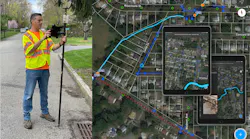
Photos courtesy Esri.
Mobile workers capture storm and sewer assets in ArcGIS Field Maps paired with an Eos Arrow Gold GNSS receiver. Supporting media such as photos helps create a complete digital twin of the city’s storm and sewer systems.
Asset Management
Ditching Paper Maps for Digital Apps
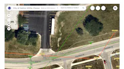
Images courtesy of the City of Saline
Today, every Public Works Department employee at the City of Saline can view digital, accurate maps of the city’s water and wastewater systems using an ArcGIS Online web map viewer like this one.
Sponsored
Home
Forward-thinking municipality implements high-accuracy maps for program management
You May Also Like
Distribution
Mapping in the Mountains
Sponsored
Water Utility Management
Industry Perspective: VertiGIS
Home
Bentley acquires AR2Tech
Load More Content